User:Ac001/Approach Procedures Tutorial
Jump to navigation
Jump to search
| Flight College |
|---|
Bovingdon Approach
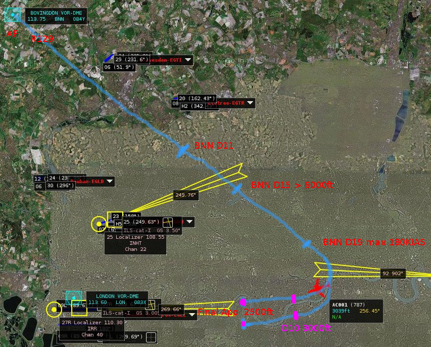
The Bovingdon Stack is a busy holding point over the BNN VOR 113.75 transmitter, about 30km north of EGLL-Heathrow. The track is over the finals for Northolt and London City airports below. To give you an idea of the procedure, following is a simplified map, procedure with comment and cockpit view of the published document AD 2-EGLL-7-16 from NATS titled:-
Initial Approach Procedures (Without Radar Control) to ILS or MLS RWY 27L/R via BNN and LAM Chart
Leave BNN on BNN VOR R129 maintaining MNM holding level.
- BNN is the IAF - Initial Approach Fix.
- The aircraft need to be heading south east the 129 radial.
- Minumum holding level is usually 7000ft.
- There's a speed limit of < 200kts under 7000ft over London (and speeding fines).
At BNN D11 descend to cross BNN D15 not below 6000 descending to 3500.
- BNN D11 - 11nm away from BNN vor start descent.
- BNN D15 - 15nm from BNN, make sure aircarft above 6000ft
- then descend down to but no lower than 3500ft
At BNN D19 at MAX 180KIAS turn right onto localiser I-LL (Rwy 27L) or I-RR (Rwy 27R), as instructed by ATC, descending to 3000, to be established by I-LL/I-RR D10.
- This is a descending turn to final and subject of cockpit view below.
- BNN D19 - 19nm away from BNN, with a maximum speed of 180kias, turn right heading 270...
- ... towards Heathrow runways/ILS for 27L and 27R
- and descend to 3000ft
- D10 - 10nm away from the airport, you should have intercepted the ILS (the DME transmits, but not the beam).
At I-LL/I-RR D10 descend to 2500, then continue the ILS/DME, LOC/DME or MLS/DME instrument approach procedure as detailed on the instrument approach charts.
- 10nm from the threshold descend to 2500ft
- and then continue to "capture" the glidescope and descend with your speed/descent/performance requirements, to a succesful landing with the gear down.
Radio Settings
- NAV1 has been tuned to the 110.3 the ILS for 27R and radial 270 selected.
- NAV2 has been tuned to the BNN station on 113.75 with radial 129 selected.
- On the 787 below, NAV1 and NAV2 are VOR L and VOR R respectively.
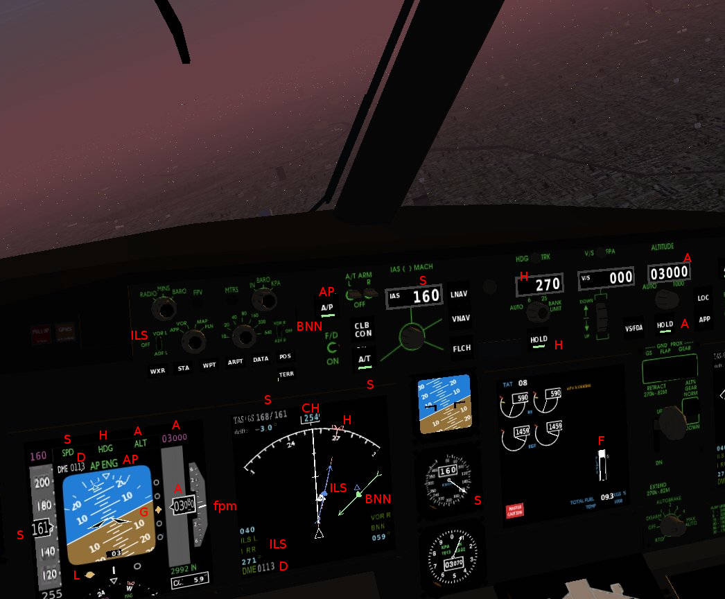
Cockpit view of turn to final
- The aircraft is positioned as on the map above and is nearing the end of an almost 140 degree descending right turn to finals for EGLL 27R.
- The AP autopilot is engaged and commanding the altitude, speed and heading of the aircraft.
- The AP button on the glareshield is green/engaged, the top middle of the PFD shows in green AP ENG
- EGLL 27R is ahead 11.3 nm at 1 oclock, height is 3500 and the next step is to prepare for landing.
Initial Approach
- BNN vor was the Initial Approach Fix, NAV2 is tuned to 113.75 and the 129 radial.
- BNN on the glareshield left - the switch is up in the VOR R position and displayed in green on the nav display below.
- BNN on the nav display - the green dot shows the location of the station, the arrow is the 129 radial the aircraft has just turned right heading away from.
- The bottom right of the nav display shows VOR BNN ident.
ILS
- NAV1 has been tuned to 110.3, the ILS frequency for RWY 28R and the 270 radial selected.
- ILS on the glareshield - VOR L is in the up position and diplayed in blue on nav display.
- ILS on nav display bottom left - shows ILS and DME below indicates the aircraft is 11.3nm from the 27R threshold.
- ILS in middle of nav display - the blue blob is the runway threshold and the arrow is pointing 27'0
- D on the PFD - DME 011.3 indicates the aircraft is 11.3 nm from the runway.
- L on the PFD - the aircraft had picked up the localiser and indicates the path is to the right.
Heading
- CH on the nav display - the aircraft is currently heading 254 on a right hand turn.
- H on the glareshield - the autopilot is in Heading HOLD as the button is engaged. The heading is 270 displayed on LED, the aircarft is turning towards the ILS.
- H on the PFD - the HDG at the top indicates that the Heading is under autopilot command.
- H on the nav display - The heading bug is at 27 = 270
Speed
- S on the glareshield - the AutoThrottle A/T button is engaged, the IAS is set to 160 as displayed .
- S on the PFD - the aircraft is travelling at 161 knots displayed on left bar, the green SPD at the top indicates that the autopilot is commanding speed.
- S on the nav display top left - displayed are TAS/GS (Target Air Speed/Ground Speed)
- S is also a backup analog display in the middle with needle pointing to 160.
- F - the flaps are down slightly and the engines have throttled back as descent increases speed.
Altitude
- A on glareshield - the Altitude HOLD button is green and engaged. The target altitude is 3000 as shown on the LED display.
- A on the PFD - the purple 3000 is the target altitute set on the glareshield. The green ALT on top indicates the autopilot is commanding in "altitude hold" mode. A on the right side shows the aircraft is nearing 3000ft at the bottom of a descent.
- fpm on the PFD right - the descent rate displayed by needle is around 500fpm, aircraft is leveling out.


