FlightGear Newsletter January 2015

|
Development news |
In the hangar |
Wiki updates |
Development news
Release preparations
Per our release plan, the release branches have been created on January 17. From that day onwards, no new features have been pushed, meaning that we have a feature-complete version 3.4 available for testing. Those interested in giving it a try can grab a release candidate from this location or build FlightGear from the release/3.4.0 branch. Bugs can be reported at our bug tracker.
FlightGear 3.4 will be released on February 17.
TerraGear LOD experiments
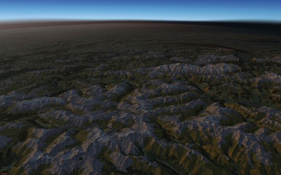
Here's a screenshot 100,00 ft above LIMA with my custom simgear - ALS enabled, and view distance increased to 400 km - remember - this is corrine data, with OSM, over mountains. About the worst case scenerio.
The results give great frame-rate, but there are issues. Currently I simplify a rectangle, and it's neighbor. the edges will most likely no longer match. When I load them together to simplify the next level, the mesh is no longer manifold, so CGAL won't add some triangles. these are showing up as black.


| I was trying to look at generating arbitrary tile sizes, and simplifying geometry for supporting several levels of detail - to be loaded by Mathais' .SPT OSG file loader plugin.
To get a baseline, I was using terrasync scenery and starting at LIMA. I would set bare LOD to 120km, zfar to 130 km, and set visibility to 120 km. Then, using the UFO, climb straight up to 100,000 ft. I would turn off random objects and building, and I customized simgear to ignore everything in the .STG file except airport and terrain .btg files ( no shared/static models ) With current fg/sg/fgdata, this would take 12.5 GB of memory. Conversations on IRC lead me to believe that this was crazy - the number of triangles/vertices was way too low to use so much memory. So I decided to gut simgear of anything 'unnecessary' for converting .BTG to OSG arrays. I found I could reduce the memory footprint by 60%! |
| I am not using the OSG simplifier. Its performace is great, but the quality, not so much. I'm using an offline simplifier, that will be used to generate larger tiles for the .SPT directory structure. see: FGViewer.
|
| I've submitted a merge request already with the changes in my simgear repo. It only addresses what I feel, is an issue with how the random trees, building, and objects retrieve tile geometry. Every tile has a LOD information attached to it, so the data in this structure should be very small. Current simgear copies pretty much the entire tile into it. Even if you run simplify far, you have the original un-simplified tile geometry for every tile loaded. My simgear changes remove the tile geometry and the cached localized material set from the LOD node, so we can load many more tiles using less memory. When the tile is within range for trees and random buildings, the material cache is rebuilt ( it's really fast compared to most of the other work done), and retrieves the tile geometry from the scenegraph itself. no extra memory needed.
|
New ATC client
"Happy new year! I brought you a cake..."
A new ATC client for the FlightGear network has been announced on the forum, called ATC-pie. It is comparable to OpenRadar, but essentially designed for realism. It has begun its beta-testing phase this month, and is expected to be called stable by February.
Several testers have put their hand up to try, some quite experienced ATCs, and their feedback was very much appreciated. Both major public live maps already show connected ATC-pie clients with the appropriate ATC icon, which makes this new little program feel fully welcome in the multi-player excitement.
ATC-pie is programmed in Python3 for Qt5, so both must be installed, as well as the python3-qt5 bindings. That done, it is meant to work straight away, with no other resource to install or make/compile command to run. No need to install or update FlightGear, download scenery or fetch any external resource before it can run.
Aircraft documentation
A tool for generating documentation based on the aircraft available in FlightGear was announced on the forum. It parses it's checklists and renders a nice .PDF. It's possible for the aircraft developers to add additional information to the .PDF. The Boeing 777 series serves as an example. The documentation will be published on a central location, check out the new wiki page Documentation compiler for more information. More features for this generator are being suggested; any feedback is welcome!
A generic canvas Navigation Display for Airbus aircraft is being developed by artix as discussed on the forum. It is implemented as an extension to Gijs' original ND code, by adding an Airbus-specific style to the code. It features all different modes (ILS, VOR, MAP, ARC and PLAN), navaids, route and hold patterns, altitude and speed markers, chronometer and so on.
It's currently available in a development branch of the canvas hackers repository and it can be easily implemented on any Airbus aircraft with just a few lines of code (you can see a sample here).
On the same repository you can also find an initial implementation of a live WXR layer for MapStructure based on omega95's original proof-of-concept and also updated/adapted by artix (it can be used on both Boeing and Airbus ND as well as in the canvas map dialog). It fetches weather radar images from an online service (Wunderground) and it renders them on the map. An API Key is required in order to use the online service.
The WXR layer has been implemented with a focus on being aircraft-agnostic, i.e. is also already being supported by the Boeing-specific NavDisplay style (as it can be found on the 747 and 777 maintained by Gijs and Hyde respectively).
For these features to become sufficiently generic in nature, it would be great to have more aircraft developers involved wanting to adopt the new Airbus ND on their Airbus aircraft, this will ensure that the underlying implementation will be as flexible and complete as necessary. If you'd like to help with this, please get in touch via the Canvas forum.
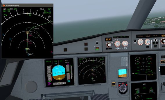
Airbus Canvas ND with Route and Hold pattern
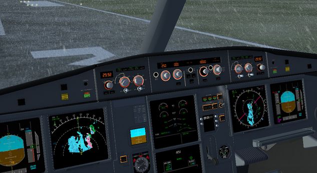
Airbus Canvas ND with Live WXR layer


In the hangar
De Havilland Canada DHC-6 Twin Otter

Since approximately one year the Twin Otter, originally created by Syd Adams is under development again.
One area, that received a major overhaul is the visual appearance, mainly the interior: The textures of the interior have been updated and presently the cabin and the cockpit are photo-realistic textured, which let the cockpit look quite impressive. See the screenshot on the right.
Besides that there are now some more instruments implemented, like a DME or a Garmin G196, which make navigation much easier.
Another important improvement is that the new Twin Otter is now Rembrandt ready.
Also the electrical systems of the Twin Otter, which were modelled pretty simple before, have been updated primarily by lanbo64: In the new version you are able to follow standard procedures to fly the Twin Otter, which improves realism a lot.
The wiki page has been updated, too, now containing some more documentation, screenshots and videos of the Twin Otter.
On the forum the Twin Otter is still under active development, so you can download the latest version there. If you have any idea on how to make the Twin Otter yet better, please feel free to contribute!
Scenery Corner
TNCM custom scenery - flood fixed
User:Legoboyvdlp has created a custom scenery that fixes the flood at Sint Maarten's TNCM airport. He requests that any of you that know of any other flooded airports please to notify him on his talkpage. This custom scenery is available at https://github.com/legoboyvdlp/LegoTNCMScenery
Slovenia

Slovenia is a small European country "on the sunny side of the Alps". User:Laserman added 3300 scenery objects, mostly power pylons but also 990 churches and 50 castles which look very nice on the hills and in the villages. Enable random buildings if your hardware can do it.
Suggested airports:
- LJCE
- LJLJ
- LJPZ
Suggested flights:
- takeoff from LJCE and explore the cities Krško, Brežice and Sevnica
- takeoff from LIPQ and follow the coast to LJPZ
Wiki updates
Unplanned downtime
During some regular maintenance from the wiki's host on January 21, the server file system got moderately scrambled. Running "fsck" (similar to dos chkdisk) is the only option, and that found a ton of problems and the wiki maintainers had to do a lot of things to bring the file system back into consistency. If anyone cares about the gory details, quite a few files were dumped into /lost+found and given #inode_number names.
There were multiple off line backups available, though in order to preserve all changes (including recent ones), Simon and Curt spend a lot of time to restore the system. The wiki was put back in shape on January 26. There may still be a few missing images that need to be recovered, but the overwhelming majority is safe.
Update to MediaWiki 1.24
On February 1, the MediaWiki software was updated to the latest stable 1.24.1 release. Coming from the previous 1.23 major release, this brings plenty of new features and improvements. An extensive overview can be found in the release notes.