Howto:Creating a custom waypointlist pendant using Canvas
Jump to navigation
Jump to search
| This article is a stub. You can help the wiki by expanding it. |
Background
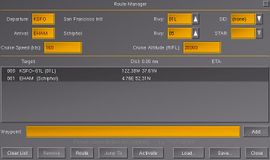
The issue is that even on the larger screens, you can't get the entire list of SIDS or STARs displayed when there are too many.[1]
Status / Todo
- Add simple helper function for creating tables consisting of vbox/hbox layouts, so that the current appearance can be emulated.
- for each row, add 3 buttons using a common callback handler
XML Markup
https://sourceforge.net/p/flightgear/fgdata/ci/next/tree/gui/dialogs/route-manager.xml#l596
        <waypointlist>
            <name>list</name>
            <halign>fill</halign>
            <valign>fill</valign>
            <stretch>true</stretch>
            <pref-height>150</pref-height>
            <property>/sim/gui/dialogs/route-manager/selection</property>
            <binding>
                <command>dialog-apply</command>
                <object-name>list</object-name>
            </binding>
        </waypointlist>
Dialog Builder
https://sourceforge.net/p/flightgear/flightgear/ci/next/tree/src/GUI/FGPUIDialog.cxx#l1051
C++ Widget Code
https://sourceforge.net/p/flightgear/flightgear/ci/next/tree/src/GUI/WaypointList.cxx
The Route Manager
Nasal APIs
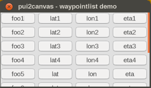
Canvas Code (proof-of-concept)
See also Pui2canvas.
| Work in progress This article or section will be worked on in the upcoming hours or days. See history for the latest developments. |
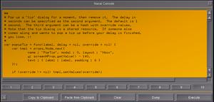
For the sake of rapid prototyping, the following snippet of code is to be executed/tested using the built-in Nasal Console:
# for faster testing, let's use a vector with dummy data to be shown matching the columns of the hard-coded widget:
var dummyData = [
 {target: 0, latitude:0, longitude:0, ETA:0},
];


var (width,height) = (320,160);
var title = 'pui2canvas - waypointlist demo';

# create a new window, dimensions are WIDTH x HEIGHT, using the dialog decoration (i.e. titlebar)
var window = canvas.Window.new([width,height],"dialog").set('title',title);


##
# the del() function is the destructor of the Window
# which will be called upon termination (dialog closing)
# you can use this to do resource management (clean up timers, listeners or background threads)
window.del = func()
{
  print("Cleaning up window:",title,"\n");
# explanation for the call() technique at: http://wiki.flightgear.org/Object_oriented_programming_in_Nasal#Making_safer_base-class_calls
  call(canvas.Window.del, [], me);
};

# adding a canvas to the new window and setting up background colors/transparency
var myCanvas = window.createCanvas().set("background", canvas.style.getColor("bg_color"));

# creating the top-level/root group which will contain all other elements/group
var root = myCanvas.createGroup();

var vbox = canvas.VBoxLayout.new();
myCanvas.setLayout(vbox);

 var scroll = canvas.gui.widgets.ScrollArea.new(root, canvas.style, {size: [96, 128]}).move(20, 100);
 vbox.addItem(scroll, 1);

var scrollContent =
      scroll.getContent()
            .set("font", "LiberationFonts/LiberationSans-Bold.ttf")
            .set("character-size", 16)
            .set("alignment", "left-center");

var list = canvas.VBoxLayout.new();
scroll.setLayout(list);


var addTable = func(scrollContent, list) {

var dummyData = [
{target:'foo1', latitude:'lat1', longitude:'lon1', eta:'eta1'},
{target:'foo2', latitude:'lat2', longitude:'lon2', eta:'eta2'},
{target:'foo3', latitude:'lat3', longitude:'lon3', eta:'eta3'},
{target:'foo4', latitude:'lat4', longitude:'lon4', eta:'eta4'},
{target:'foo5', latitude:'lat', longitude:'lon', eta:'eta'},
{target:'foo6', latitude:'lat', longitude:'lon', eta:'eta'},
{target:'foo7', latitude:'lat', longitude:'lon', eta:'eta'},
{target:'foo8', latitude:'lat', longitude:'lon', eta:'eta'},
{target:'foo9', latitude:'lat', longitude:'lon', eta:'eta'},
{target:'foo10', latitude:'lat', longitude:'lon', eta:'eta'},

];


foreach(var wpt; dummyData) {
 var newRow = canvas.HBoxLayout.new();
 var targetBtn = canvas.gui.widgets.Button.new(scrollContent, canvas.style, {wordWrap:0})
 .setText(wpt.target)
 .setFixedSize(75, 25);
 var latitudeBtn =  canvas.gui.widgets.Button.new(scrollContent, canvas.style, {wordWrap:0})
 .setText(wpt.latitude)
 .setFixedSize(75, 25);

 var longitudeBtn =  canvas.gui.widgets.Button.new(scrollContent, canvas.style, {wordWrap:0})
 .setText(wpt.longitude)
 .setFixedSize(75, 25);

var ETABtn =  canvas.gui.widgets.Button.new(scrollContent, canvas.style, {wordWrap:0})
 .setText(wpt.eta)
 .setFixedSize(75, 25);

 newRow.addItem(targetBtn);
 newRow.addItem( latitudeBtn );
 newRow.addItem( longitudeBtn );
 newRow.addItem( ETABtn );

 list.addItem( newRow );


} # foreach waypoint


} # addTable()


addTable(scrollContent, list);
Related
| References |


