Ramstein Air Base
 View of ETAR with some custom buildings. | |||||||||||||
| |||||||||||||
| Type | Military | ||||||||||||
|---|---|---|---|---|---|---|---|---|---|---|---|---|---|
| Owner | U.S. Air Force | ||||||||||||
| City | Ramstein-Miesenbach, Germany | ||||||||||||
| website | |||||||||||||
| |||||||||||||
| Scenery tile | e007n49 | ||||||||||||
| TerraSync | No | ||||||||||||
Ramstein Air Base is a United States Air Force base in south-western Germany. It serves as headquarters for the United States Air Forces in Europe - Air Forces Africa (USAFE-AFAFRICA) and is also a NATO installation. Ramstein is located near the town of Ramstein-Miesenbach ![]() , in the rural district of Kaiserslautern
, in the rural district of Kaiserslautern ![]() . The east gate of Ramstein Air Base is about 10 miles (16 km) from Kaiserslautern.
The host unit is the 86th Airlift Wing
. The east gate of Ramstein Air Base is about 10 miles (16 km) from Kaiserslautern.
The host unit is the 86th Airlift Wing ![]() (86 AW), composed of 6 groups, 27 squadrons and three bases in Germany, Spain, and Belgium. Its mission is the operation and maintenance of airlift assets consisting of C-130Js, C-20s, C-21s, C-40B and C-37A Gulfstream aircraft throughout Europe, Africa and the Middle East.
Also at Ramstein is the 435th Air Ground Operations Wing
(86 AW), composed of 6 groups, 27 squadrons and three bases in Germany, Spain, and Belgium. Its mission is the operation and maintenance of airlift assets consisting of C-130Js, C-20s, C-21s, C-40B and C-37A Gulfstream aircraft throughout Europe, Africa and the Middle East.
Also at Ramstein is the 435th Air Ground Operations Wing ![]() (formerly the 435th Air Base Wing) (435 AGOW), which focuses on base-support responsibilities within the KMC (Kaiserlautern Military Community). It is composed of 5 groups and 20 squadrons. The wing provides rapid mobility and agile combat support for military operations, and maintains expeditionary forces and infrastructure. Ramstein's wings are assigned to the headquarters 3rd Air Force
(formerly the 435th Air Base Wing) (435 AGOW), which focuses on base-support responsibilities within the KMC (Kaiserlautern Military Community). It is composed of 5 groups and 20 squadrons. The wing provides rapid mobility and agile combat support for military operations, and maintains expeditionary forces and infrastructure. Ramstein's wings are assigned to the headquarters 3rd Air Force ![]() also based at Ramstein AB, which controls most of the USAF Wings throughout Europe.
also based at Ramstein AB, which controls most of the USAF Wings throughout Europe.
History
Ramstein Air Base is an example of international collaboration. Designed by French engineers, it was constructed by some Germans but with imported help from workers of Italy, Portugal, Spain, Greece, and Turkey (there were very few German men to work on construction projects after WWII) and operated by the Americans. The area was nothing more than a swamp that had to be built up by two meters (six feet) in height level over the whole area. A train line was laid out from Einsiedlerhof-Kaiserslautern in a yoke shape around to the current base and back down to the Landstuhl spur in 1948 by agreement of the U.S. and French Occupational Forces. Trainload after trainload of earth was moved over the line and spread over the base current area to raise it to its current level. The trains ran 24/7 for over a year. Once the ground was level, building construction could begin. A project designed and undertaken by the French Army and the U.S. Army Corps of Engineers from 1949 to 1952. Two bases were laid out. Landstuhl Air Base on the south side and Ramstein Air Station (station, no airstrip) on the north. From 1948 to the opening of the bases in 1953 it was the largest one spot construction site in Europe employing over 270,000 Europeans at one time.
Technical characteristics
Communications
FGCom frequencies
Note The following table takes into account some frequencies available only in the current development version.
| Type | Frequency |
|---|---|
| ATIS | 142.120 |
| TWR | 123.550 |
| TWR 2 | 133.200 |
| GND | 121.770 |
| CLNC DEL | 120.100 |
| RMS | 081X |
Custom scenery
J Maverick 16 is currently redesigning the airport from scratch so that the scenery is as faithful as possible to the real air base. The airport will be submitted for inclusion in the international scenery as soon as the ground layout and the most important buildings are done; further updates (more buildings, boundaries, decorations, etc.) will be released via TerraSync.
Progress
| Note The following table takes into account improvements available only in the current development version. |
| Task | Progress | Remarks |
|---|---|---|
| Runway, beacon, PAPI, Tower | Beacons have been moved out of rwys, the two runways are against satellite imagery, PAPI and Tower are aligned, only some fine tunings. | |
| Taxiway layouts | Deleted false taxiway and currently editing the others. | |
| Taxi signs | Only the most important ones. | |
| Aprons | Currently under development. | |
| Buildings | A lot to do. | |
| Parking positions and ground net | Only some net and parking positions. | |
| Comprehensive air base scenery |
ATC services (USAF_RS)
ATC service is provided regularly on weekends, using also Mumble and FGCom - check Lenny's website for the exact times and dates, but usually on Friday evenings. For further information about LIPQ, use SkyVector and GCMAP. To avoid pilot/ATC misunderstandings see the minimum list of best practices. Don't simulate an emergency or found an excuse to land/take-off from Ramstein only because it is controlled in that moment, especially for airliners (e.g. terrorists on board, engine failures, passenger with cardiac arrest, President on board,...) Due to the proximity with EDDF, airmen from/to the base should not interfere with commercial traffic, especially when the airport is manned.
A word on hijackers
Recently one (or two) ATC guys used the same callsign (USAF_RS) to do ATC at ETAR, but he (or they) weren't the real USAF_RS (J Maverick 16). Due to this, all ATC sessions hosted by J Maverick 16 at Ramstein AB are going to be added on Lenny's ATC website at least a day before the session.
Screenshot gallery of ETAR
Current layout version
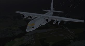
A C-130 overflying Ramstein AB at twilight.
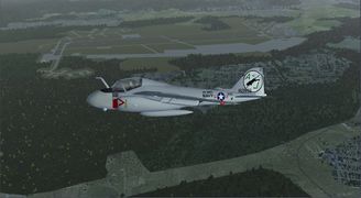
An A-6E Intruder passing close to ETAR.
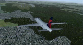
A Boeing 767-300 approaching to Ramstein.


