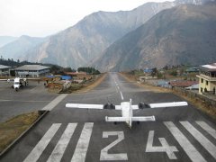
Lukla Airport
 | ||||||||||
| Type | Public | |||||||||
|---|---|---|---|---|---|---|---|---|---|---|
| City | Lukla, Nepal | |||||||||
| ||||||||||
Introduction
Built by Sir Edmund Hillary in the 1960's, Lukla Airport (recently renamed in honour of Tenzing and Hillary) provides a starting point high in the Himalayas for people attempting to climb Everest.
Lukla is only a short hop from Khatmandu (VNKT). It is an asphalt strip, a little over 500m length. The strip has a steep 10° incline, and is completely enclosed by the mountains at one end. Thus, landing is in only one direction (RWY 06) and there is no circuit. Due to the altitude, terrain and physics of the strip, Lukla is only serviced by helicopters and Twin Otters. Most traffic arrives from Khatmandu.
The Twin Otter is the recommended aircraft for Lukla.
Approach Procedure
"...From (Khatmandu) VNKT climb to at least 13000 ft while following VOR 112.30 outbound on track 096° for about 70 nm. Now turn on terrain mode (TERR) on your GPS navigator and carefully locate the low elevation valley running north and south with VNLK on its path. Follow the valley to the north while descending to just above the airport elevation at 9100 ft. When you have the airport in sight on your right side line up with the 2500 ft asphalt runway at 60° and land... " Courtesy of forum.aerosoft.com.
If GPS isn't your preferred method, it is just as easy to fly the 096° radial from Kathmandu, then turn north onto the 010° radial of Lamidada NDB 236 as you intersect it. This heading takes you straight into the valley to Lukla. Most aircraft will allow both these to be dialled in on seperate displays at the same time.
Make sure your descent from FL130 on the turn is made without delay, there isn't much time before the airport appears ahead on your right. Full flaps are a must.
Departure Procedure
Depart the airfield to the South, climb toward FL130. Using Khatmandu VOR 112.3, turn west onto the 096° radial as you intersect it. Clear of the mountains, descend 7000ft. Don't be tempted to descend any lower, as after a 6-8 min stretch without mountains, there is one more range to hop over. Once past, descend as able and prepare for an imminent landing. As the plains stretch away beneath you, the runway should become visible. If not, immediately overhead the VOR, turn north. The airfield is within a mile or two of the VOR.
Complexity
On approach, the landing happens from a descending turn onto a short final. There is a visual perception that can place the plane too low without any time to correct. Terrain makes the go-around very difficult.
Departure is easier. Add an extra level of flaps to give some extra lift on take off.
FlightGear Scenery
The required scenery for VNLK is e080n20.tgz. This tile includes Kathmandu.
External links
- Wikipedia: Lukla Airport
- Image: Lukla From The Ground (Courtesy of Airliners.net)
- Image: On Final For 06 (Courtesy of Airliners.net)