Suggested custom scenery
Besides the official TerraSync scenery that is automatically synced while FlightGear is running, there are a number of custom sceneries available, created by users for beautifying some specific areas of the scenery. This page is a list of some suggested custom scenery for downloading and visiting. This list can not be complete as custom sceneries might come and go. It's worth to search the forum for additional custom sceneries.
FlightGear 2020.3.7 and later will automatically download buildings, roads, pylons, and other objects, based on Open Street Map (OSM) data - see OSM2City 1st world build. You don't have to download OSM2City custom sceneries for these anymore. (March 2021)
Quick update, March 2020/May 2020:
- See Suggested_airports for a quick list of featured airports situated in well developed regions, with links to OSM2City scenery. It's suitable for newcomers to start at to explore surrounding regions. (March 2020)
- Project3000 adds a lot of clutter and buildings to airports which do not have models or details. It's a must have. It is planned to be integrated into the FG core eventually. Forum thread. (March 2020)
- OSM2City scenery buildings, roads, pylons, and other objects, for the whole planet is now on TerraSync, and automatically downloaded by FlightGear 2020.3.7 and later. The current OSM2City output on TerraSync is from the 1st world build of OSM2City scenery (forum thread). Custom sceneries for countries and regions are available here. Note: Old custom sceneries (before March 2021) will contain folders for OSM2City output like Buildings, Roads or Pylons with outdated and obsolete objects. These folders will override the new higher quality and faster rendering objects from TerraSync. Remember to remove these from your custom scenery folder list! If your custom scenery contains sub-folders that are not obsolete, like Terrain, you can leave these alone and only delete OSM2City sub-folders in your custom scenery folder. There are some OSM2City custom sceneries that are not obsolete - these have builds of OSM2City with different options from the 1st worldbuild - for example, custom scenery with auto-generation on in areas without good OSM coverage like the Hawaii custom scenery. (March 2021)
- Custom terrain & region definition projects: There are ongoing scenery enhancement projects to update both regional definitions and terrain in large areas like the Australia (regional definitions are planned to be added to FG core). This a partial list, search the scenery forum for details. Some of the output of projects like Hawaii terrain has already been integrated into Terrasync. (March 2020)
- Status of terrain in Terrasync: Terrasync scenery which is automatically downloaded has high resolution terrain. All of Europe currently has high resolution terrain from CORINE data. A lot of old pre-world scenery 2 should be obsolete. (March 2020)
- Status of next generation of scenery technology: World Scenery 3.0: There is ongoing work being done towards WS 3.0 which will use Virtual Planet Builder (VPB) toolchain from the Open Scene Graph project, whose scenegraph is already used in Flightgear. A prototype of the world scenery technology is available in the FlightGear next branch, and an example scenery for the current prototype is available (March 2021). For more information see the World Scenery 3.0 Roadmap. To help with the WS 3.0 effort contact the team via the "fg-devel" mailing list.
- Status of next world-build of scenery: World Scenery 3.x: There is ongoing work towards the next world build - see the the World Scenery 3.0 roadmap. Contributing land cover and terrain data currently used in custom sceneries to the central repository when it's established in future will help get work into WS 3.0. It is intended for there to be a way to contribute improvements back to a central source. For example, a landcover shapefile server. People who have generated higher quality landcover and terrain for custom sceneries from multiple sources should keep in touch with WS 3.0 development to get their contributions in the next world build. Clipped landcover shapefiles from various sources used for WS 2.0 have been available for a while and re-generated in preparation for a new world scenery build, see this mailinglist post. WS3 development is organised via the "fg-devel" mailing list. (March 2021)
- Status of terrain in custom sceneries: The page as it stands is missing almost all custom terrain. Some old island custom sceneries have been merged into the automatically downloaded sceneries terrasync. Kansas/Midwest and Tennessee are two examples of custom sceneries that aren't obsolete (March 2020).
- If you are the creator of an island scenery you can add it to TerraSync by contacting the flightgear-devel mailing list.
- Status of regional definitions in FG core: Areas with regional definitions and materials which use recent engine features, that are in areas with reasonably high resolution terrain, have extremely high fidelity at high settings. The following list is not comprehensive. It's just off the top of my head.
- Areas with regional definitions and materials that were updated with recent features like overlays and have high resolution terrain:
- Hawaii, Norway, Iceland, Sweden, Mediterranean landscapes (Spain, Sicily, Portugal, southern Italy, Greece).
- Areas with partial overlays and developed scenery with high resolution terrain:
- Swizerland, Alps (in many countries), central Europe & England, Corsica.
- Well developed areas with regional definitions that predate overlays:
- Alaska, Caribbean Islands, Bermuda, South America (lower res terrain), Grand Canyon, California (USA), Mojave Desert (lower res terrain than Europe), Madagascar (lower res terrain than Europe).
- Somewhat recently developed areas:
- South Africa in places (lower res terrain), Dubai, Mediterranean part of Africa.
- Areas with regional definitions and materials that were updated with recent features like overlays and have high resolution terrain:
- If you are the author of an existing scenery that has regional definitions and/or GPL compatible textures that are an improvement to what is present in FGData (Checklist), you can add it to FGData by having it reviewed and merged. Regional definitions can be merged even when the terrain part cannot be merged until a rebuild of the complete landmass is done.
New scenery for the Americas (January 2024)

New scenery is available for all of the Americas, including islands geographically or politically associated with them (such as Greenland, the Hawaiian Islands, Bermuda, and the Galapagos). This is intended to replace the current default TerraGear scenery as soon as we're ready to rebuild osm2city for it. The scenery includes many more airports (5-10x as many as the default scenery, most with correct taxiways and aprons), detailed inland water, and detailed 30m digital elevations. See FlightGear Americas Scenery (custom) for download details.
This scenery is suitable for use as a default to fill in the gaps between some of the more-detailed custom-scenery areas listed below.
Custom scenery that is not obsolete (May 2021)
This is only a fraction of available scenery (May 2021). Search the scenery forum for more.
See How to install custom scenery packages.
- USA, Tennessee: custom scenery for Tennessee by Scott Giese(xDraconianx). This is very high resolution scenery created to test potential resolution & performance for the next world scenery build. See the forum thread for feedback and more info. See the wiki page for downloads. (March 2020)


- USA, Kansas & Ohio: custom scenery for the entire states of Kansas and Ohio created by Wlbragg. This high resolution scenery includes textures. See the wiki page for downloads and info. (March 2020)


- Scandinavia: custom scenery covering Scandinavian countries such as Norway, Sweden, and Finland by D-ECHO. Norway and Sweden have some of the most detailed regional definitions using recent engine features. This custom scenery project further improves it by mainly adding more detailed land type classification, digital elevation data, as well as updated airports. As of March 2020 it updates parts of these countries. See the Scandinavia Custom Scenery page for download and details.
- USA, Pennsylvania, New Jersey, and New York City: custom scenery for these Eastern US states by montagdude. See forum thread. Contains custom terrain, OSM2City, and custom materials. (September 2020)


- USA, Virginia, Maryland, Delaware, and the District of Columbia: custom scenery for these Mid-Atlantic US states by montagdude. See forum thread. Contains custom terrain, OSM2City, and custom materials. (April 2020)
- USA, Rhode Island and southeastern Massachusetts: custom scenery for Rhode Island and southeastern parts of the state of Massachusetts by montagdude. See forum thread. Contains OSM2City. (March 2020)
- USA, Champaign, Chicago, Milwaukee and surrounding areas: custom scenery for Champaign, Bloomington, Chicago, Milwaukee and northern Illinois by pb321. See forum thread and to report issues. Contains OSM2City and (optional) color corrected USGS orthophotos. (May 2021)


- USA, Oshkosh, Green Bay, U.P. of Michigan and surrounding areas: custom scenery for Oshkosh, Appleton, Green Bay and the central Upper Peninsula of Michigan by pb321. See forum thread and to report issues. Contains OSM2City and (optional) color corrected USGS orthophotos. (May 2021)


- Venezuela: Project Venezuela: custom scenery for Venezuela by J. Redpath, with improved airport layouts, and objects at several airports. Highly improved over TerraSync status. (March 2020)
- Canary Islands: custom scenery for the Canary Islands by D-ECHO with improved terrain, objects, vegetation, building, reworked airports, mostly with buildings and furniture. Check out the wiki page. (March 2020)


- Argentina: OSM-based custom scenery for Argentina and parts of Chile and Uruguay by Barta.
Updated airports, landcover from OSM polygons, line data and objects using Osm2City. Updated frequently!
Downloads:
- All output: http://scenery.bartatech.net/ . As of July 2020 these areas are available: Santiago (including Valparaiso), Mendoza, Buenos Aires, complete Rosario area. The other parts only have terrain (no roads, buildings etc). The server will eventually contain all of the sceneries in the southern cone of South America: Argentina, Chile, Uruguay.
- It's possible to use the scenery.bartatech.net server directly as a Terrasync server. Just use the following in the launcher or .fgfsrc file:
- --prop:/sim/terrasync/http-server=http://scenery.bartatech.net/
- Buenos Aires province: https://github.com/bartacruz/scenery-6040
- Cuyo Area + Santiago: https://github.com/bartacruz/scenery-cuyo
- All output: http://scenery.bartatech.net/ . As of July 2020 these areas are available: Santiago (including Valparaiso), Mendoza, Buenos Aires, complete Rosario area. The other parts only have terrain (no roads, buildings etc). The server will eventually contain all of the sceneries in the southern cone of South America: Argentina, Chile, Uruguay.
- USA, Florida: custom scenery for Florida by J. Redpath with both terrain and OSM2City. It also covers the Space Shuttle landing site at KTTS. See the repository downloads section for the zip-file.
- London, England: custom scenery by J. Redpath for the London area including an improved Gatwick Airport (ICAO: EGKK). See the forum thread and repository downloads section for the zip-file.
- Moscow area, Russia: custom scenery by J. Redpath for the Moscow area covering 14 tiles. See the forum thread for the github download. (August 2020)
- Valdivostock area, Russia: custom scenery by J. Redpath for the Vadivostock area. See the forum thread for the github download. (August 2020)
- Eastern China: custom scenery by J. Redpath for the eastern portion of China covering the area around ZSAM and ZSNJ airports. See the forum thread for the github download. (August 2020)
- Beijing area, China: custom scenery by J. Redpath for the area around Beijing covering 15 tiles. See the forum thread for the github download. (August 2020)
- Sri Lanka: 2019 custom scenery by J. Redpath for the island of Sri Lanka in the Indian ocean including rebuilt terrain, OSM2City output, and improved airports. See the forum thread for github download.
- Dominican Republic: 2021 custom scenery by flc972 for Gregorio Luperon International Airport (MDPP) with detailed modeling of interiors, night lightmaps, ground net and animated jetways as well as some terrain. The airport is located on the Caribbean island of Hispaniola. See the forum thread for bitbucket download .
- Turkey: custom scenery including 12 airports. Can be downloaded from https://github.com/Klaudiae/FGCompanion-TurkeyEnhanced
- Turkey, Şanlıurfa: custom scenery by TheFGFSEagle. Can be downloaded from https://github.com/TheFGFSEagle/LTCS-scenery
- Poland: custom scenery including 14 airports. Can be downloaded from https://github.com/Klaudiae/FGCompanion-PolandEnhanced
Custom scenery set to be merged into TerraSync and FGData
These are now in the process of being merged. If you know of custom sceneries of islands or complete landmasses that have not been merged yet, contact the developers. (March 2021).
- New Zealand scenery (forum thread). (March 2020)
- Australian custom scenery project output - Regional definitions, and textures. See these forum threads for download and details: official thread, demo scenery install details (March 2020). A partially completed Sydney airport (YSSY) is also available for download. The terrain in the demo scenery release is likely to be merged when a re-build of Australia is done.
- All Channel Islands (Jersey, Guernsey, Alderney, Sark, etc) (github). (March 2020).
- Sri Lanka, forum thread and Github
Custom scenery which has been merged into TerraSync and FGData
You can remove old scenery folders containing known merged sceneries from your scenery folder list.
- Islands merged recently (2018-2019): Hawaii, Iceland, Island of Jan Mayen (Norway)
Old and undetermined custom scenery
Some of these may have been obsoleted by the release of the new world scenery in November 2013.
Please move sceneries that aren't obsolete into other categories.
- France: Custom scenery for France with improved landcover information and more detailed elevation information (no improvements on the objects) is under development. See the Custom France Scenery page. (Pre WS 2.0)
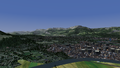
High detail France scenery
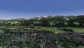
High detail France scenery

High detail France scenery

Mont Blanc

Aguille du midi?

Matterhorn without landclass, just slope transitions


- Innsbruck (Austria) area: The scenery currently covers a 1x1 degree area containing parts of Austria and Germany, and makes use of accurate data from the Corine Land Cover, and Open Street Map projects. See this forum post and the August 2009 newsletter for details. (Pre WS 2.0)
- LOWI & Austria Scenery Preview: This scenery includes the Innsbruck scenario and is much more complete than the previous. It is still experimental, but should try it as having been really good. Info and download can be found here.
- Iberian Peninsula: Spain and Portugal: custom scenery for Spain and Portugal with improved landcover and additional airports and objects. See the custom Spain and Portugal scenery page.
- EDDK: Custom scenery for the Cologne/Bonn airport in Germany with very nice and realistic terminal buildings. Available from https://github.com/mherweg/EDDK-fg-CustomScenery.
- Argentina: OSM-based custom scenery for Argentina and parts of Chile and Uruguay.
Updated airports, landcover from OSM polygons, line data and objects using Osm2City. Updated frequently!
Downloads:- Buenos Aires province: https://github.com/bartacruz/scenery-6040
- Cuyo Area + Santiago: https://github.com/bartacruz/scenery-cuyo
| |||||