Naval Support Facility Diego Garcia
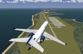
 Overview of Diego Garcia NSF in the current version with some custom buildings. | ||||||||||
| ||||||||||
| Type | Military (Naval Air Facility) | |||||||||
|---|---|---|---|---|---|---|---|---|---|---|
| Owner | UK Ministry of Defence; US Navy, Air Mobility Command (users) | |||||||||
| City | Diego Garcia Island, Chagos Archipelago, British Indian Ocean Territory | |||||||||
| website | ||||||||||
| ||||||||||
| Scenery tile | e072s08 | |||||||||
| TerraSync | No | |||||||||
Diego Garcia is an island atoll located south of the equator in the central Indian Ocean and part of the British Indian Ocean Territory, among thousands of other small islands located within British Indian Ocean Territory. The United States Navy operates Naval Support Facility (NSF) Diego Garcia, a large naval ship and submarine support base, military air base, communications and space-tracking facility, and an anchorage for pre-positioned military supplies for regional operations aboard Military Sealift Command ships in the lagoon.
History
The uninhabited islands are asserted to have been discovered by the Portuguese navigator, explorer and diplomat Pedro Mascarenhas in 1512, first named as Dom Garcia, in honour of his patron, Dom Garcia de Noronha when he was detached from the Portuguese India Armadas during his voyage of 1512–1513, but there is little corroborative evidence for this. Another Portuguese expedition with Spanish explorer of Portuguese origin, Diego García de Moguer, rediscovered the island in 1544 and named it after himself.
In the future other explorers arrived on the island and there are many other versions ![]() about the origin of the name of the island that will not be written in here.
about the origin of the name of the island that will not be written in here.
Diego Garcia and the rest of the Chagos islands were uninhabited until the late 18th century. From 1881 until 1888 Diego Garcia was the location of two coaling stations for steamships crossing the Indian Ocean.
In 1942 the British opened RAF Station Diego Garcia and established an advanced flying boat unit at the East Point Plantation, staffed and equipped by No 205 and No 240 Squadrons, then stationed on Ceylon. Both PBY Catalina and Short Sunderland aircraft were flown during the course of World War II in search of Japanese and German submarines and surface raiders. Following the conclusion of hostilities, the station was closed on 30 April 1946.
In the early 1960s, the UK was withdrawing its military presence from the Indian Ocean, and agreed to permit the United States to establish a Naval Communication Station on one of its island territories there. The United States requested an unpopulated island belonging to the UK and ultimately the UK and United States agreed that Diego Garcia was a suitable location. To accomplish the UK/United States mutual defense strategy, in November 1965, the UK purchased the Chagos Archipelago, which includes Diego Garcia, from the then self-governing colony of Mauritius for £3 million to create the British Indian Ocean Territory (BIOT), from which the United States would conduct its military activities in the region. On 30 December 1966, the United States and the UK executed an agreement which permits the U.S. to use the BIOT for defense purposes for 50 years (through December 2016), followed by a 20-year optional extension (to 2036) to which both parties must agree.
To the United States, Diego Garcia was too prime a territory to not set-up a foreign military base. According to a civilian working for the Navy at the Pentagon, Diego Garcia was located far away from any potential threats, it was low in a native population and it was an island that was not sought after by other countries; for it lacked economic interest. To him, Diego Garcia and other acquired islands would play a key role in maintaining U.S. dominance. Here he designed the strategic island concept, where the U.S. would obtain as many less populated islands as possible for military purposes. According to him, this was the only way to ensure security for a foreign base. Diego Garcia is often referred to as "Fantasy Island" for its remoteness. The key component in obtaining Diego Garcia, was the lack of Native persons on the island. Prior to setting up a Military base, the United States Government was informed by the British Government-the "owners" of Diego Garcia- that Diego Garcia only had a population within the hundreds, this was in fact proven to be false; the Chagossians numbered within the two thousands. Regardless of population numbers, the Chagossians simply had to go. In March 1971 United States Naval construction battalions Seabees arrived on Diego Garcia to begin the construction of the Communications Station and an airfield which ended in 1973. In the early 1970s, setbacks to United States military capabilities caused the United States to request, and the UK to approve, permission to build a fleet anchorage and enlarged airfield on Diego Garcia. In the early 1980s, the United States received permission for a $400 million expansion of the military facilities on Diego Garcia consisting of two parallel 12000 ft runways, expansive parking aprons for heavy bombers, 20 new anchorages in the lagoon, a deepwater pier, port facilities for the largest naval vessels in the American or British fleet, aircraft hangars, maintenance buildings and an air terminal, a 1,340,000 fuel storage area, and billeting and messing facilities for thousands of sailors and support personnel. In 1981, the naval air facility was commissioned. It was decommissioned in 1987 and its responsibilities returned to the NSF. The Strategic Air Command began deploying Boeing B-52 Stratofortress bombers and aerial refueling aircraft to the newly completed airfield facilities in 1987. Beginning on 7 October 2001, the U.S. again commenced military operations from Diego Garcia using B-1, B-2, and B-52 bombers to attack enemy targets in Afghanistan following the attacks on New York City and the Pentagon. Bomber operations ceased from the island on 15 August 2006.
Technical characteristics
Runway
The naval air facility has only one runway (122°/302°), 3,659 m long and 61 m wide. Both runways 13 and 31 will have got a BAK-12 aircraft arresting systems for emergency landings and training of eventual jets and embankments at the very end of the runways to avoid planes end in the water in case of broken brakes, ecc. in the beta version.
- Both directions are used for takeoffs (though runway 13 is preferred).
- Runway 31 is used for visual landings.
- Runway 13 is suitable for all landings and is served by an ILS system (frequency: 200.00 MHz).
Layout
The layout is simple with on single runway, one taxiway, and two big aprons: the first, on the left side of runway 13 and the second one (biggest) in the middle of the air base.
Communications
FGCom frequencies
(The following table takes into account some frequencies available only in the current development version.)
| ATIS | 282.000 |
|---|---|
| TWR | 126.200 |
| GND | 118.400 |
| APP | 134.100 |
| AMC OPS | 128.000 |
| NKW | 057X, | 00 NM |
|---|
| NDG | 200, | 127.6 deg, | 2.0 NM |
|---|
Custom scenery
J Maverick 16 is currently redesigning the airport from scratch so that the scenery is as faithful as possible to the real naval air facility. The airport will be submitted for inclusion in the international scenery as soon as the ground layout (nearly done) and the buildings are done; further updates (more buildings, boudaries, decorations...) will be released via TerraSync.
As of today, it's very difficult to find scenery materials for create with TerraGear the custom scenery so it would be very helpful if someone finds them and send them to J Maverick 16 on the main forum via PM.
Progress
The following table takes into account improvements available only in the current development version.
| Task | Progress | Remarks |
|---|---|---|
| Runway, beacon, PAPI, Tower | Only minor adjustments left. | |
| Taxiway layouts | All the taxiways have been converted from the standard layout to the airport's layout. | |
| Taxi signs | ||
| Aprons | All aprons have been designed. | |
| Buildings | Some have been added with the current version (as seen in the img above), but need to be completely replaced with the new one. | |
| Parking positions, ground net and lights | Most of the ground net and the lights have been added, but need to be checked; have to do the parking position which aren't a lot. | |
| Comprehensive air base scenery |
ATC services (NAVY_DG)
ATC service is provided with OpenRadar (occasionally with Mumble) sometimes on the afternoons and in the evenings (probably on Monday) - check Lenny's ATC website for the exact times and dates, but usually sessions are unplanned and during weekdays. Only military traffic is allowed.
FlightGear space program
| This article is a stub. You can help the wiki by expanding it. |
The naval air facility is part of the space program missions as airport-landing facility for both the Space Shuttles and other planes involved in the project. See the links for further information.
Screenshot gallery of FJDG
WED Development


Old layout version
Very old view of the naval air facility (notice that at that time, the airport was developed).

Current layout version
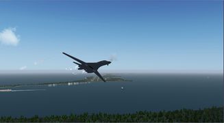
B-1B Lancer just set off from Diego Garcia.
