User:Www2/NextNav
Introduction
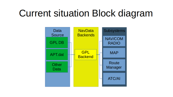
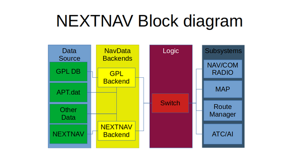
As we know is that one of the current weakness of FlightFear is that our NavAids database is out of date and don't support things as airspace, GBAS, GLS, LAAS, HF comm, etc. The goal of the NextNav project is for closing the gap between flight gear and other flight sims as MSFS2020 and xp12 in the area of navigation data set. This is not to replace our current data-set (in the rest of this document i call this data-set GPL data-set) but the new data-set is an optional data-set that need be enable by the user by downloading demo datasets from FlightGear servers or the current datasets navigraph.
The NextNav database is call sim424 this name come from airnic 424 standard. The database it self is an set of sqlite database that is using that are locate in $FGHOME/NavData/NextNav, $FGROOT/NavData/NextNav/ and $scenery/NavData/NextNav.
- NavDB_navdata_earth.nndb
This is the general datasets from Navigraph and is the key for enable flightgear NextNav dataset mode instate of the GPL datasets. Other files that is include in this dataset is cycle.json is use for displaying the AIRAC cycle that the dataset are using. fileformat: sqlite
- NavDB_Legacy_earth.nndb
This file contain Procedures for Legacy airports as Kai Tak (VHHX/VHXX) Hong Kong and Berlin Templehof (EDDI) and routs as Concorde NAT routes. fileformat: sqlite
- NavDB_patch_earth.txt
this is an patch file that is use to add/modified navaids in navdata for use in a custom scenery. fileformat: json
- NavDB_user_earth.nndb
This are custom Navdata that are create by the user. fileformat: sqlite
- Alias_earth.csv
This file is use for airports that have multiple ICAO codes or two airports that share runways. e.g. Kai Tak (VHHX/VHXX) for a airport with 2 icao code and Daniel K. Inouye International Airport (PHNL)/Hickam Air Force Base (PHIK) as an airports that share runways. fileformat: CSV
block diagram
tools
The foaling list are tools needed to be create for this project.
This is the tool that generate the Navdata form Navigraph database.
Standalone Test tool (high priority)
This tool is create for helping testing the new data format and helping to create better models for navigation equipment.
editor (medium priority)
The editor that is use for helping creating custom scenery and add/remove navaids.

