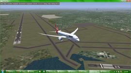
Brisbane International Airport
| This article is a stub. You can help the wiki by expanding it. |
 | |||||||||||||
| Type | Public | ||||||||||||
|---|---|---|---|---|---|---|---|---|---|---|---|---|---|
| City | Brisbane, Queensland (QLD), AUSTRALIA | ||||||||||||
| website | |||||||||||||
| |||||||||||||
Brisbane International Airport is the international and domestic airport serving the city of Brisbane. The airport is located approximately 15km from Brisbane City, near the mouth of the Brisbane river on an area that had sand pumped from Morton Bay to raise it above tide levels. The Brisbane FIR en-route centre is located adjacent to Brisbane tower and controls all of Queensland, the Northern Territory, half of Western Australia, Northern half of New South Wales (from just north of Sydney) and the Tasman Sea.
Runways
YBBN has 2 runways, the main north-south 01/19, and a SE-NW 14/32 to the north west of rwy 19 used by G.A. aircraft.
Runway 01/19
Runway 01/19 is the airports longest runway at 3 560 metres long. Instrument Landing System is available for both runway 01 and runway 19.
| Runway | NAV Freq | ILS Ident | Heading | FAF Name | Intercept Altitude |
|---|---|---|---|---|---|
| 01 | 109.5 | IBA | 016 | GLENN | 3000ft |
| 19 | 110.1 | IBS | 196 | SINNK @ 2500ft | 7.1DME at 2500ft |
Runway 14/32
Runway 14/32 is used by General Aviation and is 1 700 meters long. There is no Instrument Landing System available.
Airport Layout
The International terminal is the South West quadrant of the airport, next to that is the Domestic Terminal in the western half and the next to that is the General Aviation apron in the North West quadrant.
Scenery
Models for the the whole airport are available from an external source [3].