File:Navigation display MAP mode.png
Jump to navigation
Jump to search
No higher resolution available.
Navigation_display_MAP_mode.png (400 × 400 pixels, file size: 69 KB, MIME type: image/png)
Summary
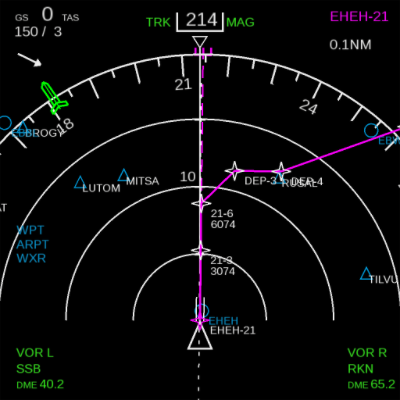
| Description | (en) Navigation display MAP mode while on the runway at Eindhoven Airport (EHEH). Route planned to Amsterdam Airport Schiphol (EHAM). |
| Date | 26 December 2013 , 23:49:55 |
| Source | Own work |
| Author | Gijs |
|
Location on Earth |
|
View this and other nearby images on: Google Maps - Google Earth OpenStreetMap | (Info) |
|---|
Licensing
|
File history
Click on a date/time to view the file as it appeared at that time.
| Date/Time | Thumbnail | Dimensions | User | Comment | |
|---|---|---|---|---|---|
| current | 22:50, 26 December 2013 | | 400 × 400 (69 KB) | Gijs (talk | contribs) | User created page with UploadWizard |
You cannot overwrite this file.
File usage
The following 5 pages use this file: