| Title: |
Remove dependency on BTG files for WS3.0 land-use processing in osm2city 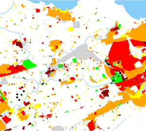 Visualisation of land-use processing in osm2city based on WS2.0 BTG files combined with OSM data. |
| Sponsors: |
vanosten
|
| Interested Parties: |
(feel free to add yourself)
|
| Status: |
PROPOSED
|
| Summary: |
Currently osm2city is using BTG files to access some scenery data, which is either needed for alignment due to the difference between OSM and FG scenery (coastlines) or is not consistently available in OSM depending on the region (e.g. urban land-use). However, BTG files are not anymore present in WS3.0. Therefore osm2city land-use processing has to be adapted to use different data sources (most of it OSM).
|
| Background: |
|
| Details: |
- See parameters.OWBB_USE_BTG_LANDUSE and parameters.USE_WS30_SCENERY around line 820 in landuse.py.
- We will use Edinburgh as testbed due to ports, coastline and available WS3.0 scenery.
- Virtual_Planet_Builder and World_Scenery_3.0_roadmap specify possible data sources. Need to decide whether to use raster data to be as close to VPB input as possible - or just use reasonable vector data for what is at the core why BTG data was used in the first place: detect urban areas, which are not mapped in OSM.
|
| Required skills: |
Python. Alternatively C++ as Rick is prototyping a migration of osm2city from Python to C++ for various reasons.
|
| Learning Opportunities: |
- Get acquainted with programming in osm2city
- Geographic information processing with OSM data
|
| Notes: |
Need to work on the ws3 branch.
|
