File:MapStructure dialog with clipping and event handling applied.png
No higher resolution available.
MapStructure_dialog_with_clipping_and_event_handling_applied.png (413 × 334 pixels, file size: 29 KB, MIME type: image/png)
Summary
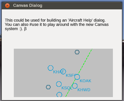
| Description | (en) Screen shot showing TheTom's modified demo dialog with a MapStructure based map that has clipping and event handling applied, i.e. can respond to common mouse events in order to either display tooltips or support drag&drop-style GUI dialogs for editing map-like displays, e.g. for creating an Advanced weather GUI[1]. Particular care must be taken to formalize z-index handling (rendering priority) for each MapStructure layer, which is something we still need to work out, especially for possibly overlapping symbols... |
| Date | 28 June 2014 , 23:34:23 |
| Source | Own work |
| Author | Hooray |
Licensing
|
File history
Click on a date/time to view the file as it appeared at that time.
| Date/Time | Thumbnail | Dimensions | User | Comment | |
|---|---|---|---|---|---|
| current | 21:36, 28 June 2014 | | 413 × 334 (29 KB) | Hooray (talk | contribs) | User created page with UploadWizard |
You cannot overwrite this file.
File usage
The following 3 pages use this file: