Summary
| Description |
(en) WS30 view of West Lothian, with 25m resolution landclass data, vegetation, osm2city buildings, and OSM-based roads and rivers. |
| Date |
8 May 2021
(2021-05-08) |
| Source |
Own work |
| Author |
Stuart |
Licensing
I, the copyright holder of this work, hereby publish it under the following license:

 
|
This file is licensed under the Creative Commons Attribution-Share Alike 4.0 International license.
You are free:
- to share – to copy, distribute and transmit the work
- to remix – to adapt the work
Under the following conditions:
- attribution – You must attribute the work in the manner specified by the author or licensor (but not in any way that suggests that they endorse you or your use of the work).
- share alike – If you alter, transform, or build upon this work, you may distribute the resulting work only under the same or similar license to this one.
|
|
|
|
|
File history
Click on a date/time to view the file as it appeared at that time.
| Date/Time | Thumbnail | Dimensions | User | Comment |
|---|
| current | 20:19, 8 May 2021 | 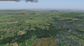 | 2,488 × 1,376 (5.26 MB) | Stuart (talk | contribs) | Uploaded own work with UploadWizard |
You cannot overwrite this file.
File usage
The following page uses this file:

