
No higher resolution available.
Summary
| Description |
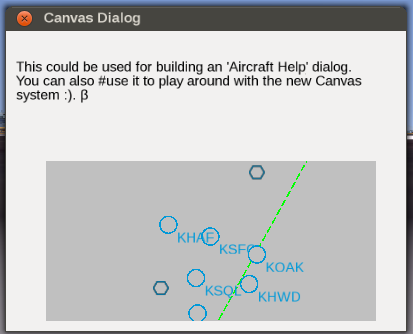
(en) Screen shot showing TheTom's modified demo dialog with a MapStructure based map that has clipping and event handling applied, i.e. can respond to common mouse events in order to either display tooltips or support drag&drop-style GUI dialogs for editing map-like displays, e.g. for creating an Advanced weather GUI[1]. Particular care must be taken to formalize z-index handling (rendering priority) for each MapStructure layer, which is something we still need to work out, especially for possibly overlapping symbols... |
| Date |
28 June 2014
(2014-06-28), 23:34:23 |
| Source |
Own work |
| Author |
Hooray |
Licensing
I, the copyright holder of this work, hereby publish it under the following license:

 
|
This file is licensed under the Creative Commons Attribution-Share Alike 3.0 Unported license.
You are free:
- to share – to copy, distribute and transmit the work
- to remix – to adapt the work
Under the following conditions:
- attribution – You must attribute the work in the manner specified by the author or licensor (but not in any way that suggests that they endorse you or your use of the work).
- share alike – If you alter, transform, or build upon this work, you may distribute the resulting work only under the same or similar license to this one.
|
|
|
|
|
File history
Click on a date/time to view the file as it appeared at that time.
| Date/Time | Thumbnail | Dimensions | User | Comment |
|---|
| current | 21:36, 28 June 2014 |  | 413 × 334 (29 KB) | Hooray (talk | contribs) | User created page with UploadWizard |
You cannot overwrite this file.
File usage
The following 3 pages use this file:
This file contains additional information, probably added from the digital camera or scanner used to create or digitize it.
If the file has been modified from its original state, some details may not fully reflect the modified file.