File:MapStructure-WXR-layer-by-omega95.png
Jump to navigation
Jump to search

No higher resolution available.
MapStructure-WXR-layer-by-omega95.png (278 × 297 pixels, file size: 124 KB, MIME type: image/png)
Summary
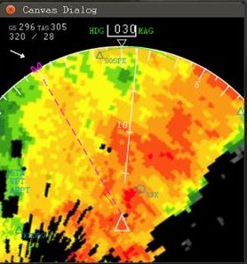
| Description | (en) MapStructure WXR (weather) layer created by omega95's using a web service API to fetch live online imagery |
| Date | 10 August 2014 , 15:45:31 |
| Source | http://forum.flightgear.org/viewtopic.php?f=71&t=23753#p216328 |
| Author | omega95 |
Licensing
{{subst:uwl}}
File history
Click on a date/time to view the file as it appeared at that time.
| Date/Time | Thumbnail | Dimensions | User | Comment | |
|---|---|---|---|---|---|
| current | 13:46, 10 August 2014 | | 278 × 297 (124 KB) | Hooray (talk | contribs) | User created page with UploadWizard |
You cannot overwrite this file.
File usage
The following 4 pages use this file: