Weather: Difference between revisions
Jump to navigation
Jump to search
No edit summary |
mNo edit summary |
||
| Line 1: | Line 1: | ||
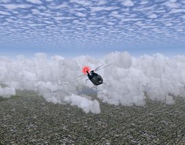
[[Image:3D_clouds.jpg|thumb|270px|[[3D clouds]] in [[PLIB]] version as seen from a [[EC135]].]] | [[Image:3D_clouds.jpg|thumb|270px|[[3D clouds]] in [[PLIB]] version as seen from a [[EC135]].]] | ||
FlightGear has an impresive weather system, including real weather fetch, [[3D clouds]] and lightning. | FlightGear has an impresive weather system, including real weather fetch, [[3D clouds]] and lightning. | ||
Revision as of 19:21, 25 March 2009
FlightGear has an impresive weather system, including real weather fetch, 3D clouds and lightning.
METAR
A METAR is a codified observation message indicating an airfield weather conditions observed at a given time. There are different ways of messaging weather reports, but in FlightGear is METAR used.
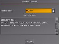
The METAR-message can be found acros the menu (Weather > Weather Scenario). To have the actual weather (or playing with ATC) you need to enable the Real weather fetch in the FlightGear Wizard.
Such a message is established every hour.
Explanation
Example:
| 2008/03/15 12:24 | KSFO | 151224Z | 05012KT | 10SM | SN | BKN050 | 02/M08 | A3016 | RMK AO2 SLP228 | T00221083 |
| 1 | 2 | 3 | 4 | 5 | 6 | 7 | 8 | 9 | 10 | 11 |
- Date
- ICAO Identifier (4-letter)
- Issuance Time DDHHMMz (UTC)
- COR (CCD in Canada) if correction to observation
- Wind
- First 3 digits: True Wind direction or average if variable (VRB).
- Note: If the wind direction varies 60° or more, the direction will be indicated with a V (e.g. 180V250)
- Next 2 digits: Mean speed and units
- KT=knots, KMH=kilometers/hour, MPS=meters/second
- G (gust) as needed – 2 or 3 digit maximum speed
- Calm will be indicated by 00000KT
- Example: 18012G22KT 150V240
- First 3 digits: True Wind direction or average if variable (VRB).
- Horizontal Visibility
- Prevailing Visibility (PV)
- Statue miles (SM) and fractions (US & Canada only) or,
- 4 digit minimum visibility in meters, and,
- Lowest value and direction, as required (shown as a remark)
- Runway Visual Range (RVR)
- R: Runway Designator, L/R/C as needed, “/”
- P/M: Plus/Minus (US only)
- 4 digit value (feet/meters)
- V (variability) with tendency U/D/N (up/down/no change)
- Example: R18R/1200FTV/U
- Prevailing Visibility (PV)
- Present Weather (Constructed sequentially):
- Intensity
- Descriptor
- Precipitation (Dominant type is listed first if more than one type reported)
- Obscuration
- Other
- Sky Cover
- Cloud Description
- Amount in eights (octas)
- SKC=Sky Clear (clear below 12,000 for ASOS/AWOS)
- NSC=No significant clouds
- FEW=Few (1/8 to 2/8 sky cover)
- SCT=Scattered (3/8 to 4/8 sky cover)
- BKN=Broken (5/8 to 7/8 sky cover)
- OVC=Overcast (8/8 sky cover)
- Cloud Description
- Terperature/Dewpoint (whole °C) (preceded by M=minus)
- First 2 digits = temperature
- Second 2 digits = dewpoint
- Altimeter setting (QNH) and indicator (A=InHg, Q=hPa)
- Supplementary Information
- RE = Recent weather followed by weather codes
- WS = Windshear, followed by:
- TKOF/LDG (takeoff/landing)
- RWY (2 digits runway identifier and designator L/R/C)
- RMK = Remark
- SLP = Sea Level Pressure
- T00221083 (Expanded temp/dewpoint)
- 1st, 5th digits: 0=plus, 1=minus
- 2nd-4th digits: temp (decimal missing) (02.2)
- 6th-8th digits: dewpoint (decimal missing) (-8.3)
- Trend Forecast (2 hours from time of observation) (Not used in US)
- PROB and 2 digits (30 or 40) = probability 30% or 40%
- Used to indicate the probability of occurance of alternate element(s) or temporary fluctuations
- Change Indicator
- BECMG = Becoming (used where changes are expected to reach or pass through specified values
- TEMPO = Temporary (fluctuations of less than one hour duration
- NOSIG = No significant change
- Forecast Wind (same as item 4)
- Forecast Visibility (as item 5) (9999 indicates 10Kilometers vis or greater)
- Forecast Weather (as item 6)
- Forecast Cloud (as item 7)
TAF
An Aerodrome Forecast (TAF) is a concise statement of the expected meteorological conditions at an airport during a specified period (usually 24 hours).

