User:Ac001/Runway Tutorial
Jump to navigation
Jump to search
| Flight College |
|---|
Orientation
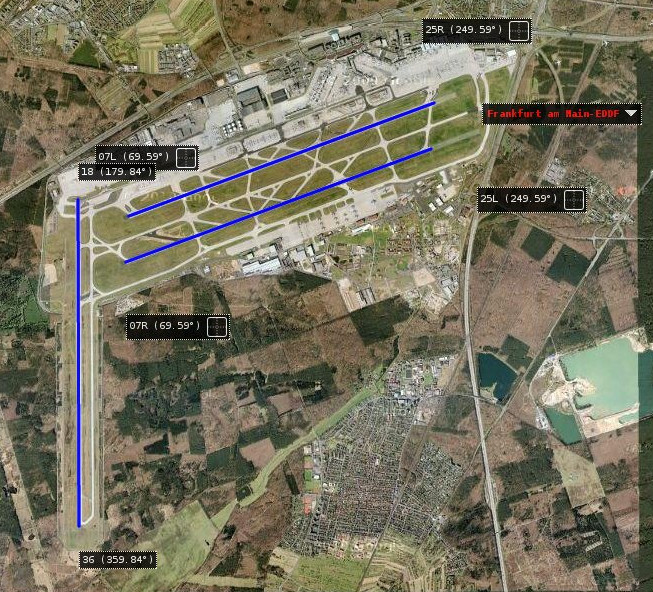
The map belows shows the three runways at EDDF Frankfurt.
- Runways (RWY) are numbered between 01 and 36 to indicate their magnetic heading (to nearest 10th degree).
- RWY 36 points north, 18 points south and 07 points NW.
- A runway can be used in both directions and therefore two names, eg RWY 18/36.
- If there are two or more runways, then L, C and R are added for Left, Center, Right, eg 07L/25R.
EGLL: 09L/27R
The diagram below from official CAA, shows the detail of the northen runway at Heathrow, EGLL 27L/27R

- The DME (top center) at 110.30 is the location of the distance measuring equipment transmitter.
- Below is the label indicating the RWY length, 3901M long and 50m wide and is designed to facilitate huge/heavy/fast aircraft, as well as small ones.
- The lines of the centre line are at 50m intervals
- Below the red T, are the green lights of the "threshold", a point at which aircraft are to land or take off after. 09L is a displaced threshold as its further onto the tarmac and a blast zone.
- Under the red P on both sides are the PAPI lights next to the "touch down zone", past the runway threshold and the expected safe landing area.
- TODO ; elevation description
- The lead in loghts and the ILS position TODO
