TerraMaster
 | |
| Developed by | reeed |
|---|---|
| Initial release |
18 July 2011 |
| Latest release |
r29, 25 February 2012 |
| Written in | Java |
| Platform | crossplatform |
| Type | Scenery manager |
| Website | |
TerraMaster is a graphical scenery manager that gives you a quick overview of your scenery and makes it easier to maintain that scenery. TerraMaster is a crossplatform application written in Java that uses TerraSync to update and download new scenery.
Using
Global view
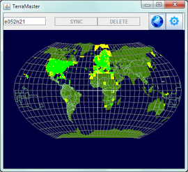
When TerraMaster starts it will show a map of the Earth. Left-clicking will zoom you in on an area. Clicking the "globe" icon will get you back to the global view.
Tile border colours
The tiles are colour coded to represent the state of the tiles:
- Green tiles have both terrain and objects. (They have been synced with Terrasync or Terramaster.)
- Amber/Yellow tiles have terrain but no objects. (And are possibly unsyncable - see "Bug", below.)
- Red tiles are currently being selected for synchronisation.
- Blue tiles are being synchronised.) As each tile is synchronised it changes to green.
Zooming and panning
Zoom using the scroll wheel.
Pan around by dragging the map while pressing the right mouse button.
Syncing tiles
To select just one tile left-click it. The scenery for download is available in 1x1 degree tiles.
To select more tiles press the Ctrl key while left-clicking or left-dragging over the wanted tiles. If you accidentally selected a tile to many, deselect tiles using it Ctrl+left-click. You can also deselect several tiles using Ctrl+left-click and dragging.
Start the update and/or download clicking the "sync" button. The tiles will be downloaded starting from the first tile you selected and proceed in order of distance from it. If you are downloading tiles for a long flight you should then begin by selecting a tile close to the departure airport.
To find the tile for a specific airport type in the ICAO code (or name) in the Search box and press Enter. If you look very carefully you can see the airport written in white and you can zoom to that tile.
When you have finished syncing tiles you can click the "world" icon, or right-click and drag to go the correct part of the world for the next batch of syncing.
Hints
To get some information about a downloaded tile, hold the mouse cursor over it. A popup box will show he name of that tile, if there are terrain and objects in it and what airports it contains. This only works if a tile has been synced, either with Terrasync or TerraMaster.
Before multiplayer events it might be an idea to sync the related tiles, even more so if you know that someone has crated new buildings etc. and got them into the scenery database.
Installing
Before installing, make sure you have Java 6 or higher, as it is needed.
- Download the newest version of TerraMaster from the download page.
- Unzip all the files in a suitably named and placed folder.
- Create a shortcut or script that runs
java -jar terramaster.jar. - When running TerraMaster the first time, click the "gear" icon and select the folder where your TerraSync scenery is located.
- Done!
Possible bug
It can happen that if you try to sync a tile with no airports TerraMaster will fail to run the next time you open it. Keep a copy of the terramaster.properties file and, when that happens, copy it over the one in the folder where you placed the TerraMaster files. You will have to click the "gear" icon again to specify the path to the Terrasync folder. You can go to TerraMaster Issues and check the Status of Issue 2 to see if it is fixed.
"Un-syncable" tiles will stay yellow.
Models
Don't forget that this is just a front-end for Terrasync, and the contents of /terrasyn/Models will have to be coped to $FG_ROOT/Models for them to be visible.
Related content
External link
- TerraMaster: a new scenery manager topic on the FlightGear forum.