Innsbruck Airport: Difference between revisions
m (Robot: Cosmetic changes) |
No edit summary |
||
| Line 41: | Line 41: | ||
== FlightGear Scenery == | == FlightGear Scenery == | ||
The required scenery for LOWI is [ftp://ftp.ibiblio.org/pub/mirrors/flightgear/ftp/Scenery-1.0.1/e010n40.tgz e010n40.tgz]. It includes all airports listed in this article. | The required scenery for LOWI is [ftp://ftp.ibiblio.org/pub/mirrors/flightgear/ftp/Scenery-1.0.1/e010n40.tgz e010n40.tgz]. It includes all airports listed in this article. | ||
== FlightGear Custom Scenery == | |||
The download contains Austria with terrain created by Tuxklok from the [http://www.flightgear.org/forums/viewtopic.php?f=5&t=14132#p141931 Austria Scenery Project] and the current state of the LOWI and Austria scenery model development. | |||
{| | |||
| Autors: || Christian Schmitt, Tuxklok, Oliver Thurau, Paolo Rota, HHS, David G. and others | |||
|- | |||
|- | |||
| Latest update: || 2012.08.05 | |||
|} | |||
[[File:LOWI area overview.jpg|700px]] | |||
youtube videos: [http://www.youtube.com/watch?v=saJEakwvEuE&hd=1 Flightgear - planespotting at LOWI], [http://www.youtube.com/watch?v=gtYMvNQHuEA&list=UUT6mwzOJlbm3PNiYz2X9Vvw&index=3&feature=plcp IAR 80 Romanian WW2 Fighter over Innsbruck] | |||
=== Download === | |||
* Download as zip os available: [http://www.multiformat.de/ftp/LOWI/LOWI-austria-PREVIEW.zip LOWI & Austria preview 2012.08.05] | |||
* For using the scenery Flightgear GIT is recommended, but it will work with fgfs v2.6 and up. | |||
=== Development === | |||
* See this [http://www.flightgear.org/forums/viewtopic.php?f=5&t=8438 forum post] for more info about the state of LOWI area development. | |||
* Generally, changes will go into the scenery DB eventually. Some yet unpublished updates are to be found in this repo: http://gitorious.org/papillon81/flightgear-custom-scenery | |||
== External links == | == External links == | ||
Revision as of 01:58, 5 August 2012
 | ||||||||||
| Owner |
Tiroler Flughafenbetriebs GmbH | |||||||||
|---|---|---|---|---|---|---|---|---|---|---|
| City | Innsbruck, Austria | |||||||||
| [Innsbtruck Airport website] | ||||||||||
| ||||||||||
Nestled high in the Austrian stretch of the Alps is Innsbruck Airport. Innsbruck is a seasonally busy airport that serves the ski/alpine industry. It takes local, national and international aviation traffic.
Use of the Innsbruck Airport is restricted to "High Performance" aircraft by Austrian authorities (see the Austro Control link below). The airport lies within a steep East-West valley, requiring non-ICAO standard procedures to approach and depart.
Procedures
Approach
Approach maps have been provided in the links below. These are sourced from Austro Control - but may not necessarily be current.
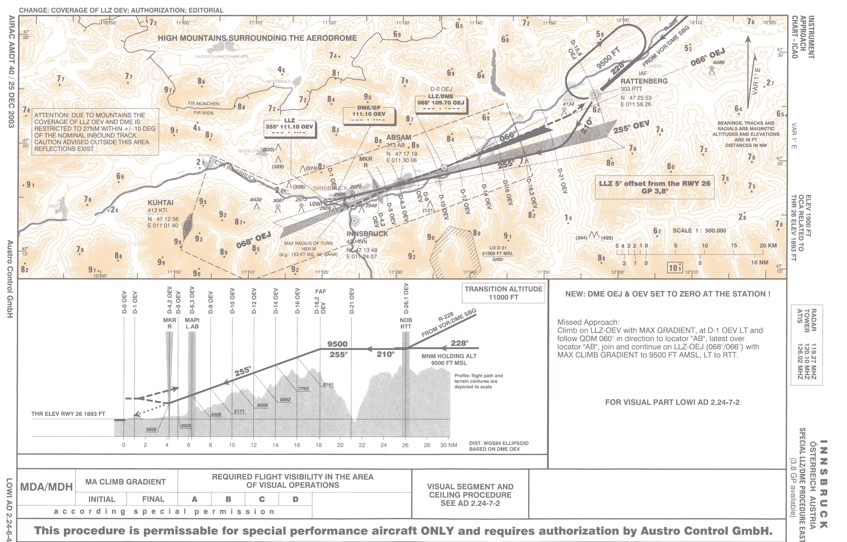
Chart: Approach From East
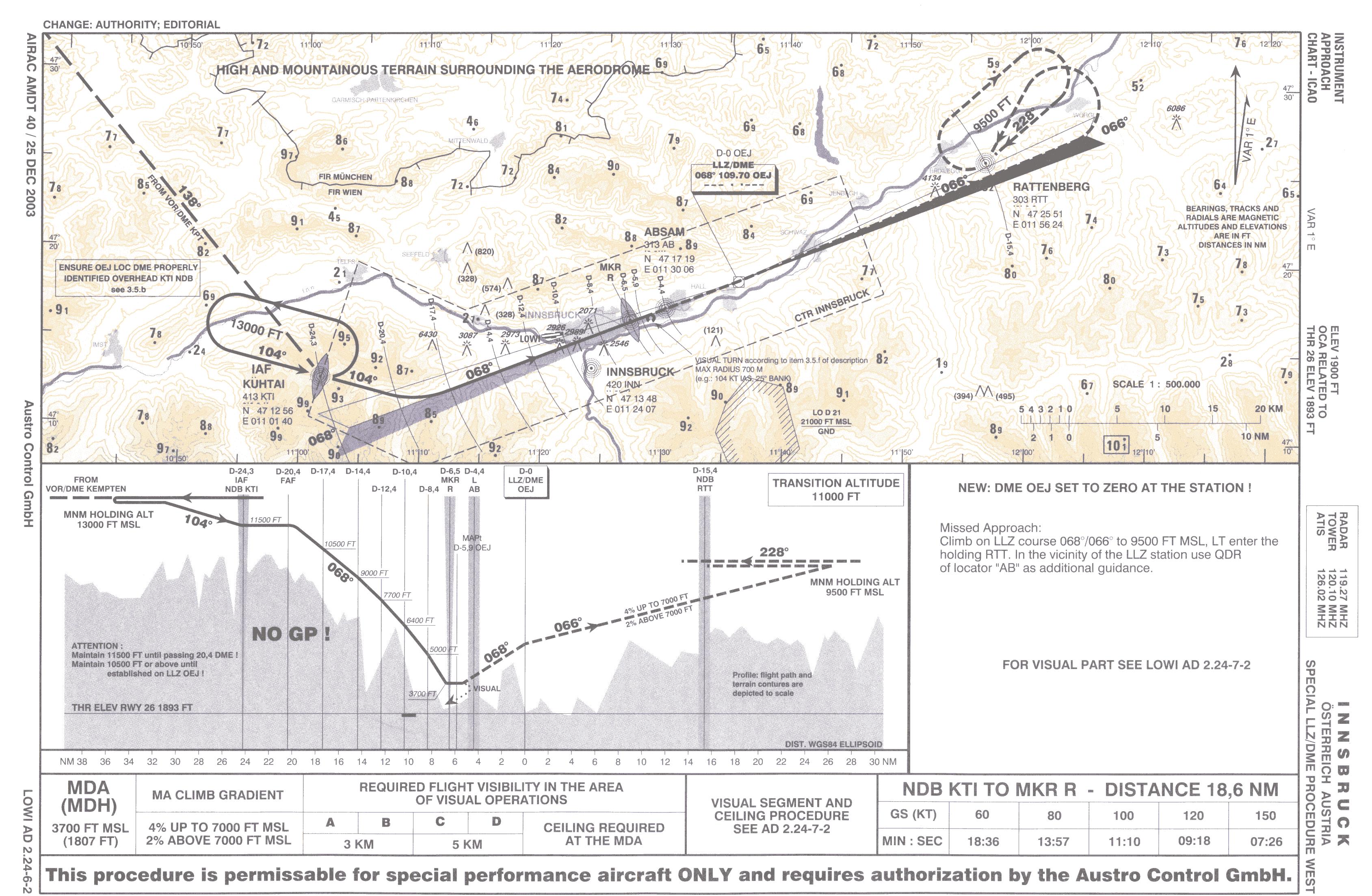
Chart: Approach From West
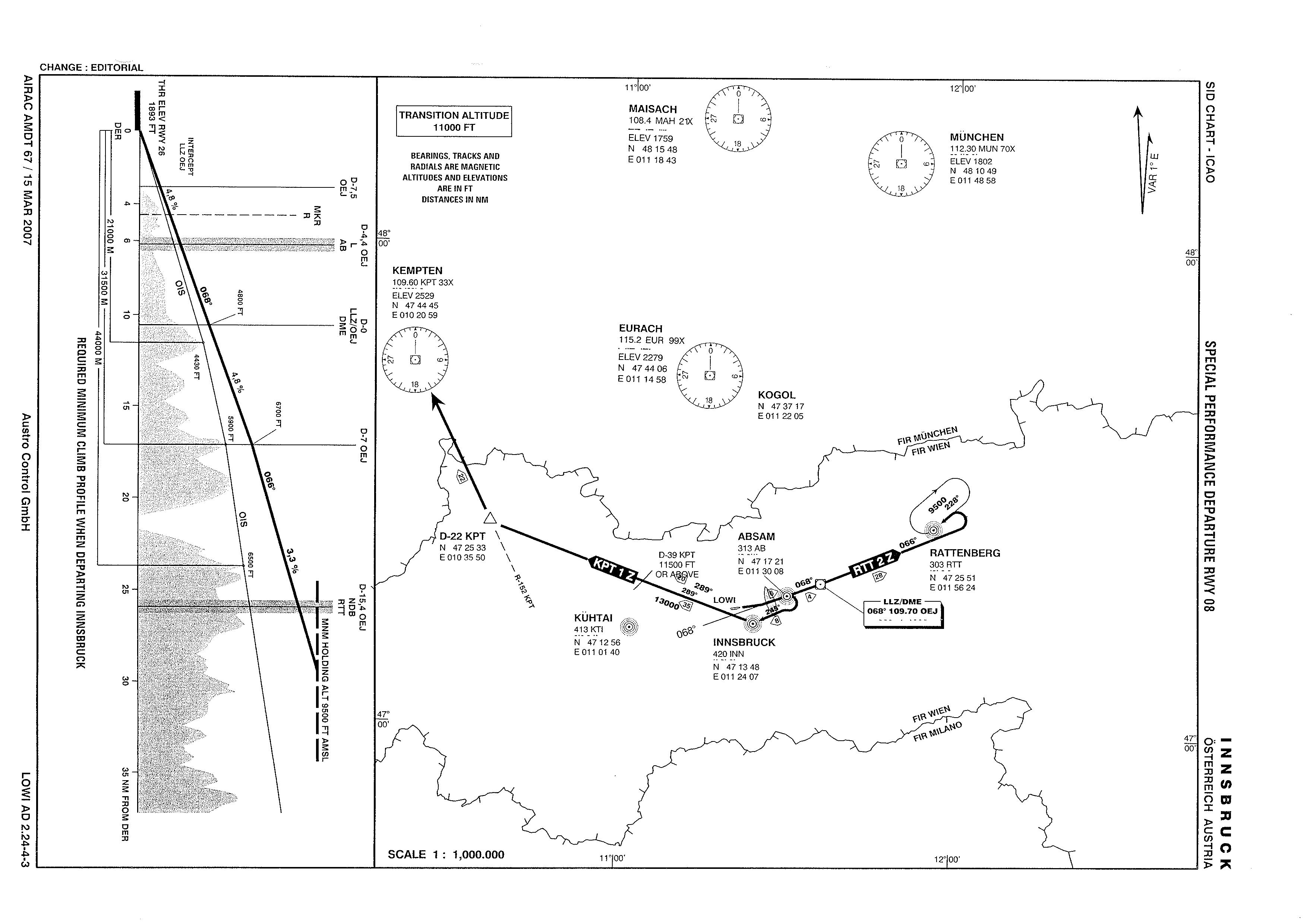
Chart: Depart East or West
Approach From The East: ILS Approach RWY 26. Navigate to the Rattenberg NDB (RTT 303) at FL100. Salzburg Maxglan (LOWS) provides a close and suitable departure runway. From overhead RTT, turn to heading 211°, descend to 9600ft and intercept the ILS (111.1). Dial in Absam NDB 313. At Minimum Descent Altitude (overhead the Absam NDB), pilot must be visual or perform the prescribed missed approach. Turn to runway heading when required and land.
Approach from the West: LLZ/DME Approach into the circuit for a RWY 26 landing. Depart airport Memmingen Allgau (EDJA), navigate to Kempten VOR (KPT 109.6). Overhead KPT, join the 138 radial and navigate to the Kuhtai NDB (KTI 413), at FL130. When LLZ (111.10) is identified (not established), depart the NDB heading 104° not below FL115. At DME 20.4 miles, commence descent, and join the LLZ. Do not proceed below FL105 if not established on LLZ. Observe minimum altitudes on descent, stop descent at 3700ft. If visual, turn final and land, otherwise follow prescribed missed approach.
Departure
Departure maps have been provided in the links below. These are sourced from Austro Control - but may not necessarily be current.
Departure to the East: Using Absam NDB (AB 313) and LLZ (OEJ 109.7), depart RWY 08 at max climb. Fly overhead the NDB, establish on the LLZ, to 9500ft.
Departure to the West: Starting on Absam NDB (AB 313) and Kempten VOR (KPT 109.6), depart RWY 08 at max climb. Cross the AB NDB not below 5600ft and make right turn to 245, for Innsbruck NDB (INN 420). Cross INN not below 9400ft, turn to KPT. Altitude must be 11500 by 39 miles out of KPT.
Complexity
Steep non-standard climb and descent angles, LLZ offset to runway heading. Try throwing some weather in for good measure.
FlightGear Scenery
The required scenery for LOWI is e010n40.tgz. It includes all airports listed in this article.
FlightGear Custom Scenery
The download contains Austria with terrain created by Tuxklok from the Austria Scenery Project and the current state of the LOWI and Austria scenery model development.
| Autors: | Christian Schmitt, Tuxklok, Oliver Thurau, Paolo Rota, HHS, David G. and others |
| Latest update: | 2012.08.05 |

youtube videos: Flightgear - planespotting at LOWI, IAR 80 Romanian WW2 Fighter over Innsbruck
Download
- Download as zip os available: LOWI & Austria preview 2012.08.05
- For using the scenery Flightgear GIT is recommended, but it will work with fgfs v2.6 and up.
Development
- See this forum post for more info about the state of LOWI area development.
- Generally, changes will go into the scenery DB eventually. Some yet unpublished updates are to be found in this repo: http://gitorious.org/papillon81/flightgear-custom-scenery
External links
- Austro Control Website: LOWI Page
- Airport Building Images: travel2austria.com