Flughafen Stuttgart: Difference between revisions
Jump to navigation
Jump to search
m (scaling images) |
(Layout update) |
||
| Line 23: | Line 23: | ||
=== Charts === | === Charts === | ||
All [http://www.vacc-sag.org/airport/EDDS diagrams and charts] are available for download. | All [http://www.vacc-sag.org/airport/EDDS diagrams and charts] are available for download. | ||
== Scenery == | |||
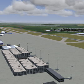
Since FlightGear 3.0 the airports layout is published on 850-standard via [[TerraSync]]. Additionally most buildings have been placed by using the large Shared-Objects database of FlightGear. | |||
Revision as of 12:54, 23 May 2014
| This airport article is a stub. You can help the wiki by expanding it. |
 | ||||||||||
| Type | Public | |||||||||
|---|---|---|---|---|---|---|---|---|---|---|
| Owner | Flughafen Stuttgart GmbH | |||||||||
| City | Stuttgart | |||||||||
| website | ||||||||||
| ||||||||||
| TerraSync | published | |||||||||
Stuttgart Airport (in German Flughafen Stuttgart, formerly Flughafen Stuttgart-Echterdingen) is an international airport located approximately 13 km (8.1 mi) (10 km (6.2 mi) in a straight line) south of Stuttgart, Germany in the federal state Baden-Würtemberg. The airport lies on the boundary between the nearby town of Leinfelden-Echterdingen, Filderstadt and Stuttgart itself.
Flying at Stuttgart airspace
Charts
All diagrams and charts are available for download.
Scenery
Since FlightGear 3.0 the airports layout is published on 850-standard via TerraSync. Additionally most buildings have been placed by using the large Shared-Objects database of FlightGear.
