Custom Spain and Portugal scenery
Custom scenery for the Iberian Peninsula is available. This area includes the continental territories of Spain, Portugal, Andorra and Gibraltar. The project uses the data from CORINE database for the land classes, OpenStreetMap for the landmass and roads and the enhanced altitudes by Jonathan de Ferranti.
Improvements over the standard scenery
The following data sources have been used and processed to generate this scenery:
- landcover information from the CORINE program. See here for the correspondence between CORINE and FG textures. Additional cities and details were manually added, specially in Catalonia.
- landmass and coastline updated according to OpenStreetMaps data,
- digital elevation data by Jonathan de Ferranti for Canary Islands, Gredos and Picos de Europa [1],
- Road and rail information from OpenStreetMap [2].
- All airports have been compiled using v850 of apt.dat
- New airports are modeled, and many existing airports and airfields have been improved.
- Lots of buildings added, especially suitable for VFR flights: notification points, cities...
The creation of the scenery is still an on-going project. Additional information and temporary data files can be found at Vive FG!
Distribution
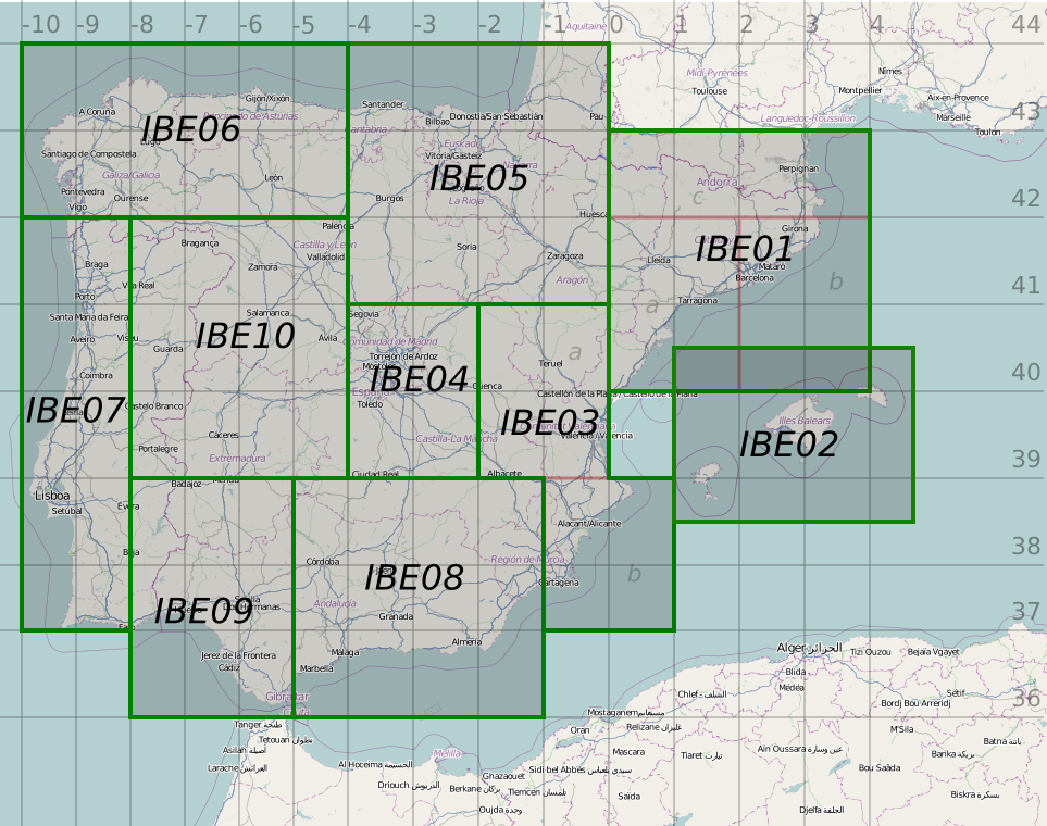
The scenery files has been divided in 10+1 zones for an efficient management of the data and updates.
- IBE01 (Catalonia): https://mega.co.nz/#!BM4WUDiI!aff4k1CBBYUyzRfWFbe_mH6pwaQ4SmypSVNaOHosWYE (348.3 MB)
- IBE02 (Balearic Islands): https://mega.co.nz/#!UAg0FLRC!cSiPZFMLelRicB-HsFN8gk8sXKBMClV9E8UWDaCVivk (39.6 MB)
- IBE03 (Valencia): https://mega.co.nz/#!cE5jXYyY!RkxuCQMGXqhz3XnQybmWzwtOg71q54sMZYThycYZC0Y (184.9 MB)
- IBE04 (Madrid): https://mega.co.nz/#!1No23JBI!U8Id3lQ7xNAJ66CmR_-Gnj8seJBdEbE9CVq-qD4RRBY (110.4 MB)
- IBE05 (Basque Country, Aragon): https://mega.co.nz/#!IdA31R7Z!BNnsHxCZ4-hIpy0QPf-gq06uwH8jquhnLLcCljk5D50 (350.4 MB)
- IBE06 (Galiza): https://mega.co.nz/#!sBZBQBQb!PVnFU1P-eVPGfbqGL3tqSSz5nPojNpBjxaGc2CMG70g (303.9 MB)
- IBE07 (Coast of Portugal): https://mega.co.nz/#!hFQgRAYb!WbJs4Q4gItiuIXTFYNJkpUGthpcd9Bbsxe0fcDU0NW8 (157.0 MB)
- IBE08 (East Andalusia): https://mega.co.nz/#!YNA1gLyY!A0edtQC-ryogA8iLvWcyrBAyZVx5r5jWduQccY8WmjE (265.2 MB)
- IBE09 (West Andalusia, South of Portugal): https://mega.co.nz/#!YcBU1IpR!ayFgMRQ2OAv-T_IQBlulJyjCPDFCkWWB-hKZ10EVmHM (167.5 MB)
- IBE10 (East Portugal, Leon): https://mega.co.nz/#!JQggGY7D!I0gi5UeSPverIYVO2siGRCRWDR0taAJP7ntlWYMApgo (321.3 MB)
- Extra zone: GC: (Canary islands): https://mega.co.nz/#!AQBnRDza!foAgxzkjzJ90s1vO50Juv0zXR-YCpATiN5gpk-VyW9c (70.4 MB)

|

|
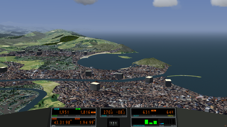
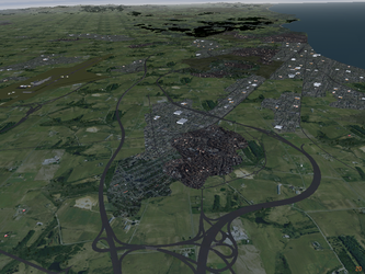
| Bay of La Concha (Airport: LESO) | Costa Daurada (Airport: LERS) |
This work is released under the terms of the Creative Commons Attribution-ShareAlike 3.0 Unported license [3].
Improved and new airports
All airports haven been compiled using v850 of the database. This means that the taxiways of most airports are hugely improved over the current scenery available from terrasync, which uses v810 of the airport data. Unfortunately, FlightGear still uses v810 to calculate positions and navaids, and hence some of the airports will be apparently displaced up to a hundred meters. We are still doing our best to fix this, but aircrafts and buildings may still appear in wrong positions after selecting some small airports.
The next map shows the improved airports in the scenery: https://maps.google.com/maps/ms?msid=200770868570711495874.0004dc0d380de0bb19925&msa=0 All these airports include custom buildings, some of them have enhanced runways and a few are completely new. The airports that are not in this map but are included in v850 of apt.dat are also compiled, but they do not include buildings. Most of the new buildings are not yet uploaded to terrasync since it still uses the old positions and elevations from v810. Some of the new starting positions are already included in the scenery files.
Color code:
- Blue: international and regional airports, usually controlled. Only airliners and general aviation. No ultralights allowed.
- Red: airfields suitable for general aviation, runway longer than 800m, usually uncontrolled and paved surface. There may be ultralights, gliders and parachutes in the area.
- Green: small airfields for ultralights. Usually uncontrolled and dirty surfaces. Runway less than 800m.
- Yellow: heliports.
- Question mark: we are working on them.
