Custom Spain and Portugal scenery
Custom scenery for the Iberian Peninsula is available. This area includes the continental territories of Spain, Portugal, Andorra and Gibraltar. The project uses the data from CORINE database for the land classes, OpenStreetMap for the landmass and roads and the enhanced altitudes by Jonathan de Ferranti.
Improvements over the standard scenery
The following data sources have been used and processed to generate this scenery:
- landcover information from the CORINE program. See here for the correspondence between CORINE and FG textures. Additional cities and details were manually added, specially in Catalonia.
- landmass and coastline updated according to OpenStreetMaps data,
- digital elevation data by Jonathan de Ferranti for Canary Islands, Gredos and Picos de Europa [1],
- Road and rail information from OpenStreetMap [2].
- New airports and enhancements to many existing airports and airfields, including LEBL, LEDA, LETO, LECS.
The creation of the scenery is still an on-going project. Additional information and temporary data files can be found at Vive FG!
Distribution
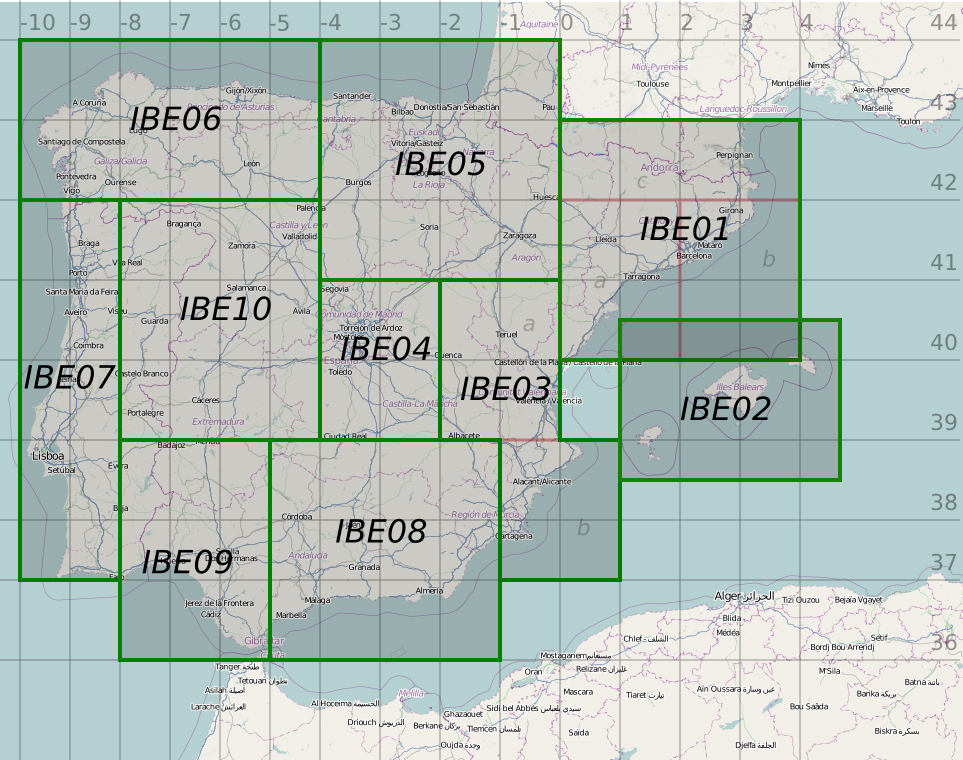
The scenery files has been divided in 10+1 zones for an efficient management of the data and updates.
- IBE01 (Catalonia): http://dl.dropbox.com/u/13130748/IBE01.zip (260MB)
- IBE01-Objects. http://dl.dropbox.com/u/13130748/IBE01-Objects.zip (7MB) Additional buildings for IBE01.
- IBE02 (Balearic Islands): http://dl.dropbox.com/u/13130748/IBE02.zip (26MB)
- IBE03 (Valencia): http://dl.dropbox.com/u/13130748/IBE03.zip (144MB)
- IBE04 (Madrid): http://dl.dropbox.com/u/13130748/IBE04.zip (100MB)
- IBE05 (Basc Country, Aragon): http://dl.dropbox.com/u/13130748/IBE05.zip (230MB)
- IBE06 (Galicia, Asturias): http://dl.dropbox.com/u/13130748/IBE06.zip (166MB)
- IBE07 (Coast of Portugal): http://dl.dropbox.com/u/13130748/IBE07.zip (143MB)
- IBE08 (East Andalucia): http://dl.dropbox.com/u/13130748/IBE08.zip (190MB)
- IBE09 (West Andalucia, South of Portugal): http://dl.dropbox.com/u/13130748/IBE09.zip (130MB)
- IBE10 (East Portugal, Leon, Valladolid): http://dl.dropbox.com/u/13130748/IBE10.zip (230MB)
- Extra zone: GC: (Canary Islands): http://dl.dropbox.com/u/13130748/GC.zip (40MB)

|

|
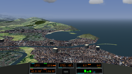
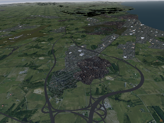
| Bay of La Concha (Airport: LESO) | Costa Daurada (Airport: LERS) |
This work is released under the terms of the Creative Commons Attribution-ShareAlike 3.0 Unported license [3].
Improved and new airports
The scenery files already include many enhanced and new airports, including their buildings, runways, taxiways and navaids. Most of the new buildings are not yet uploaded to terrasync since it still uses old airport positions. Some of the new starting positions are already included in the scenery files.
IBE01
- Barcelona - LEBL: complete reconstruction the airport by ELS [4]. Tower by Codolar, Terminal 2 by NiTuS, Terminal 1 by ludomo [5]. The updated navaids for runways 07L and 02 need manual installation. See [6].
- Reus - LERS: additional taxiways, all buildings modeled, area of the flight club included, notification points for VFR flights modeled. [7] Historic hangar for general aviation: --lat=41.144055 --lon=1.147302 --heading=70
- Lleida Alguaire - LEDA: new airport. Runway, taxiways, platform and buildings [8]. Platform: --lat=41.7290031 --lon=0.5407769 --heading=220
- La Cerdanya - LECN: buildings by ludomo
- Igualada - LEIG: generic buildings
- Avinyonet - LE01: complete reconstruction of the airfield and new models for all buildings [9]. Platform: --lat=41.3681 --lon=1.7675 --heading=180
- Lleida Alfés - LEAT: complete reconstruction of the airfield [10] Platform: --lat=41.54945190 --lon=0.65171187 --heading=150
- Huesca Benabarre - LENA: new small airfield. Runway, taxiways, platform and buildings. Platform: --lat=42.02227 --lon=0.47853
IBE02
IBE03
- Castellón Costa Azahar - LECS: new airport. Runway, taxiways, platform and buildings [13] Platform: --lat=40.205735486 --lon=0.064476113 --heading=0
- Valencia - LEVC: buildings by Codolar
IBE04
- Madrid Torrejon - LETO: complete reconstruction of the airport [14]
IBE05
- Bilbao - LEBB: buildings by Antonio Rodriguez/blcyus [15]
IBE08
- Granada - LEGR: buildings by Codolar
GC
- Tenerife - GCXO: buildings by Lukas
- La Palma - GCLA: buildings by Lukas
