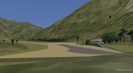
Chagual Airport
 Termial of Chagual | ||||||||||
| ||||||||||
| Type | Public | |||||||||
|---|---|---|---|---|---|---|---|---|---|---|
| Owner | Compania Minera Poderosa | |||||||||
| City | Chagual, Pataz - Sierra de la Libertad, Peru | |||||||||
| ||||||||||
| Scenery tile | w080s10 | |||||||||
| TerraSync | n.a. | |||||||||
| Download | ||||||||||
Chagual Airport is an private Peruvian airfield owned by Compania Minera Poderosa and is located near the town Chagual in the district of Pataz. Chagual is the only airfield in the district offering passenger traffic, air cargo and operations.
The Chagual airfield, 3.980 feet high in the middle of the Andes, is a small airstrip with a length of 1.200 meter encased in a winding valley which only allows a very difficult and complicated visual approach. The approach to the runway 14 is made with a substantial bank angle on final, since due to the topography is impossible to make an approach centered on the axis of runway.
Flying at Chagual
Remarks
- RWY 14 Direction 136° asphalt - Displaced Threshhold 300m/990ft
- RWY 32 Direction 316° asphalt
- RWY Dimension 1.205x18m/3.955x60ft
- Elevation 1.210m/3.965ft MSL
- Start-up position on the apron: Start
- TRU TRUJILLO 116.30MHz 079°/88.7nm
- BTE CHIMBOTE 112.50MHZ 031°/95.8nm
- MAR CAJAMARCA 300.00MHz 309°/63.6nm
- ATA ANTA-HUARAZ 415.00MHz 179°/92.8nm
ATC
FIR LIMA
- UTA 128.1, 128.8, 128.5 MHz Centro de Control de Área de Lima [above FL245]
- CTA 128.1, 128.8 MHZ Lima ACC [MEA until FL245]
- TMA 119.7 MHz Control de Aproximación
- ATZ 118.1 MHz Torre de Control
Nearby Airports
- SPGL Chagual Airport
- SPIS Pias Airport
- SPGC Gochapita Airfield
- SPAI Urpay Airfield
- SPJR Cajamarc Airport
- SPRU Trujillo Airport
High Altitude Operation
- Choose an aircraft wich allows a service ceiling more than 10.000 ft like the PC-6, B200 or AeroStar700
- Reduce the fuel to a minimum
- Reduce your load, every 10% under the gross weight increase the performance about 20%
- Choose flaps for take-off depending on the maximum deflection of the aileron. Not much more.
- Pre-lean your engine and give a bit of throttle to get the engine started
- Check your indicated airspeed again and again
Scenery
In TerraSync this airport not exist (status 01/2016). You have to download a custom scenery.
Scenery Add-on
A custom FGsenery_Chagual package is available for download. This Scenery add-on contains airport data, airport layouts, airport buildings and more which are not available via Terrasync. Note: to use the start-up positions in-sim, select your starting position via the [Location -> Select Airport] menu. Type in the name of the parking position, press enter (important!). Then select [Go To Airport].
Always get the newest development version automatically: Download the FGsenery_Chagual.zip
Features
- All airfields of the Province of Pataz included
- Sloped runways at all airfields
- Detailed, phototextured and handcolored 3D models of buildings
- fully Rembrandt compatible
- Challenging take-offs, approaches and cloud flying