ATC-pie: Difference between revisions
Mickybadia (talk | contribs) (New release: r7) |
Mickybadia (talk | contribs) (v1.6.4) |
||
| (45 intermediate revisions by 4 users not shown) | |||
| Line 6: | Line 6: | ||
| title = ATC-pie | | title = ATC-pie | ||
| logo = ATC-pie-logo.png | | logo = ATC-pie-logo.png | ||
| image = ATC-pie-screenshot- | | image = ATC-pie-screenshot-towerViewing.png | ||
| alt = | | alt = Tower viewing, following a departing aircraft | ||
| developedby = Michael Filhol | | developedby = Michael Filhol | ||
| initialrelease = February 1, 2015 | | initialrelease = February 1, 2015 | ||
| latestrelease = | | latestrelease = 1.6.4 (March 15, 2020) | ||
| writtenin = Python3 | | writtenin = Python3 | ||
| os = Any | | os = Any | ||
| Line 17: | Line 17: | ||
| type = ATC client | | type = ATC client | ||
| license = GNU GPL v3 | | license = GNU GPL v3 | ||
| website = | | website = http://mickybadia.free.fr/atcpie | ||
}} | }} | ||
'''ATC-pie''' is an [[air traffic control]] simulation program featuring solo | '''ATC-pie''' is an [[air traffic control]] simulation program featuring: | ||
* solo sessions, incl. voice instruction recognition and pilot speech synthesis; | |||
* multi-player network connections through [[FGMS]]; | |||
* tutorial sessions for teacher supervision of an ATC student. | |||
It can simulate en-route centre control (CTR) as well as airport-based services (TWR, APP, GND...), and allows 3D tower viewing through [[FlightGear]]. It is essentially designed for realism and simulates many tasks and situations of real-life ATC such as: | |||
* strip rack and sequence management; | |||
* radar monitoring and transponder identification; | |||
* handovers to/from neighbouring controllers; | |||
* routing and conflict anticipation; | |||
* flight plan filing and editing... | |||
The program is free and open source, and programmed in Python3 for Qt5 hence system-independant. Only Python3 and its Qt5 bindings must be installed. That done, it is meant to work straight away, with no make/compile command to run or external resource to install. The whole world is immediately available on radar. Tower viewing requires the appropriate FlightGear aircraft and scenery. | |||
== Screenshots == | |||
Visit the [[:Category:ATC-pie screenshots|ATC-pie screenshot category]] for more. | |||
<gallery mode="packed"> | |||
ATC-pie-screenshot-sectorView.png|Sector view around Geneva | |||
ATC-pie-screenshot-soloMode.png|Playing solo with three coloured racks | |||
ATC-pie-screenshot-backgroundPixmapDrawing.png|Background image display | |||
ATC-pie-screenshot-airportCloseUp.png|Depiction of airport tarmac and objects | |||
ATC-pie-screenshot-runwayIncursion.png|Runway incursion detected and highlighted in red | |||
ATC-pie-screenshot-flightPlans.png|Flight plan editor | |||
</gallery> | |||
=== | == Working principles == | ||
=== General === | |||
You are the air traffic controller, working with or without a tower window or radar scope, depending on your position and local facility. Players will connect to the network (multi-player), AI traffic be simulated (solo), or student traffic generated and controlled by the teacher, all with different types of aircraft, [[transponder]] equipment and intentions. | |||
As in real life if you use a radar, your main technology is [http://en.wikipedia.org/wiki/Secondary_surveillance_radar SSR], hence unless you cheat or activate the primary radar, it will show you only what you pick up from on-board transponders in its range. This means: | |||
* | * if a transponder is off or out of range, you will not see the aircraft on your radar screen; | ||
* | * if a transponder is on and in range, you will at least be able to see its position and read the transponder code, possibly its altitude and even its type and callsign, depending on the mode set by the pilot and your radar capabilities. | ||
* | |||
* | === Strips === | ||
* | [[File:ATC-pie-screenshot-stripDetailSheet.png|thumbnail|The ATC-pie strip detail sheet]] | ||
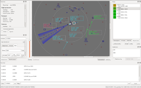
Your basic traffic flow and sequence working unit is the '''strip''', each representing a controlled (or soon expected) aircraft. Strips are created, filled with details and moved across ''racks'' and ''bays'' until handed over to a different controller or shelved. Strip details can all be manually edited, and include: | |||
* most importantly, the aircraft's ''callsign'', to be used on the radio; | |||
* information like aircraft type, airspeed, route... that can be provided by the pilots themselves when filing ''flight plans''; | |||
* transponder code and flight parameter assignments (heading, altitude/FL, air speed). | |||
=== Linking strips === | |||
Every strip can be '''linked''' to a flight plan and/or a radar contact. A linked strip will automatically: | |||
* display its missing elements when available from the linked flight plan or aircraft transponder; | |||
* populate the linked aircraft radar tag with useful details, e.g. assigned altitude. | |||
Any detail mismatch between a strip and its linked elements will be reported for you to resolve. | |||
=== Radar identification === | |||
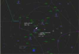
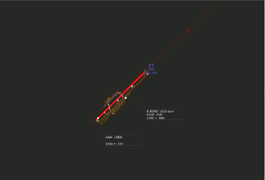
[[File:ATC-pie-screenshot-radarIdentification.png|thumbnail|Radar identification: both matched strip and radar contact marked in blue]] | |||
When using radar, ATCs can rely on different things to ''identify'' an aircraft and link the right contact to its strip. They can read an aircraft's callsign straight away if its transponder is squawking mode S, tell from reported positions, or use a transponder code. | |||
For instance, say a transponder-equipped VFR traffic makes radio contact giving their callsign and approximate position. ATC will typically pull out a new blank strip and give the pilot a unique transponder code to squawk, writing it on the strip alongside the announced callsign, then wait for it to appear on the radar. This allows for '''radar identification''' of aircraft–strip pairs such that: | |||
* the strip is assigned a transponder code; | |||
* no other strip is assigned the same code; | |||
* the aircraft is the only unidentified traffic squawking that code in radar range. | |||
ATC-pie identifies such pairs automatically and reports them to you so you can properly link the two and get back to the pilot: "radar identified". | |||
=== | == Detailed feature list == | ||
=== General === | |||
* | Available session types: | ||
* | * FlightGear multi-player network connections | ||
* | * Solo sessions (simulated IFR traffic) | ||
* Teacher–student tutoring (teacher spawns and manipulates the traffic visible to the student) | |||
For all session types: | |||
* | * Airport mode (for ATC positions such as TWR, GND, APP, DEP at a selected airfiled) | ||
* | * En-route centre (free positioning of radar, no base airport or runway-related options) | ||
Common data sources: | |||
* Airport and navigation data retrieved from [http://data.x-plane.com X-Plane] sources (whole world default file set included) | |||
* | * Editable aircraft data base (ICAO designators, cruise speeds, WTC, etc.) | ||
* | * Radar background images and hand drawings (integrated EuroScope/[http://www.vatsim.net VATSIM]/IVAO .sct sector file import) | ||
* | * Ground elevation maps (can be generated automatically with a provided script) | ||
* | * Real world magnetic declination lookup | ||
* | |||
GUI features: | |||
* | * Multiple window workspace (radar screens, strip racks and bays) saved by location | ||
* | * Floatable/dockable panels and toolbars (see [[:File:ATC-pie-screenshot-toolbars.png|screenshot]]) and layout save/restore | ||
* Customisable colours | |||
* Notification system combining selectable sounds, status bar messages and time-tagged history | |||
Misc. tools: | |||
* Quick point-to-point heading and distance measuring tool | |||
* | * Multiple weather station monitor | ||
* | * Direct text annotation of radar screen | ||
* | * World airport, map navpoint and AD parking position browsing/indicating | ||
* Aeronautical unit conversion calculator | |||
* Custom alarm clocks with quick keyboard timer start | |||
* General and location-specific notes and settings saved on close and restored on restart | |||
=== ATC surveillance === | |||
* | Radar and transponders: | ||
* | * SSR mode selection and primary radar activation | ||
* | * Full transponder support and mode-dependant radar behaviour | ||
* | * Traffic identification assistant | ||
* Runway occupation/incursion detection | |||
* Position/track vs. assignment mismatch warning system | |||
Tower viewing for airport mode (requires FlightGear): | |||
* Renders view of airport, aircraft, weather, time of day | |||
* Internally started or through an externally running instance | |||
* Control panel to orient/zoom view or follow aircraft | |||
* Additional views can be connected (for multiple camera angles) | |||
=== Traffic management === | |||
Strips and racks: | |||
* User-defined racks with configurable colours for linked radar contacts and ATCs to collect strips from | |||
* Strip auto-print for expected departures or arrivals | |||
* Runway boxes with automatic RWY separation timers | |||
* Loose strip bays with customisable backgrounds | |||
Routes, vectors, conflicts: | |||
* World route suggestions, presets, analysis, radar drawing and world map view | |||
* Convenient mouse input for vectors, taxi instructions and waypoint changes | |||
* Current leg and next waypoint display with geodesic calculations of headings and distances | |||
* Route/vector conflict anticipation and separation incident alarm | |||
* Approach spacing hints for inbound sequences | |||
Communications: | |||
* [[FGCom]] radio integration for multi-player and tutoring sessions (possible use of externally running client), incl. ATIS recording (see [[:File:ATC-pie-screenshot-ATISdialog.png|feature dialog]] with pre-filled preparation notepad), multiple frequency transmissions and monitoring, frequency-specific sound level selection | |||
* | * Radio direction finding (RDF) and integration to radar | ||
* | * Controller-pilot data link communication (CPDLC) | ||
* Public text chat in MP with preset messages, auto-completion, predefined and custom aliases for context-sensitive replacements, sender blacklist to filter out trolls | |||
ATC coordination: | |||
* Private messaging with other ATCs (text "landlines") | |||
* General ATC chat room | |||
* | * "Who has?" requests | ||
* | |||
=== | === Session environments === | ||
Strip | FlightGear multi-player sessions: | ||
* | * Strip exchange: handovers with other ATC-pie and [[OpenRadar]] instances in range | ||
* Weather: real world METAR retrieval | |||
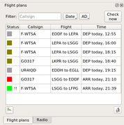
* Flight plans: interface with [http://flightgear-atc.alwaysdata.net Lenny64's data base] (the ''de facto'' FG standard), incl. run-time retrieval, opening, closing, filing and editing (work on local copies and manage sync with online status) | |||
* In-app announcement of ATC sessions on Lenny64's event page | |||
Solo sessions (AI traffic): | |||
* Strip exchange: handovers to/from virtual ATCs | |||
* Weather: randomised | |||
* | * Voice instruction recognition (with Sphinx) | ||
* | * Pilot read-back speech synthesis (with pyttsx) | ||
* | * Airline choice and custom aircraft appearence | ||
* Configurable airspace rules | |||
* Adjustable difficulty (traffic density) | |||
ATC | Tutoring sessions (teacher with student): | ||
* Strip exchange: configurable ATC neighbours and handover supervision by teacher | |||
* Weather: controlled by teacher | |||
* Traffic snapshots and recall to repeat situations with the student | |||
== Using ATC-pie == | == Using ATC-pie == | ||
To download the program and learn more about how to use it, read the ATC-pie [[ATC-pie installation guide|installation]] and [[ATC-pie user guide|user]] guides. If you have a question, check the [[ATC-pie FAQ|FAQ]] for help or try the forum. | |||
[[Category:ATC-pie]] | |||
[[Category:ATC clients]] | [[Category:ATC clients]] | ||
[[Category:Air Traffic Control]] | |||
Revision as of 13:50, 22 March 2020
| The FlightGear forum has a subforum related to: ATC-Pie support & development |
|
| |
 Tower viewing, following a departing aircraft | |
| Developed by | Michael Filhol |
|---|---|
| Initial release | February 1, 2015 |
| Latest release | 1.6.4 (March 15, 2020) |
| Written in | Python3 |
| OS | Any |
| Platform | Qt5 |
| Development status | Active |
| Type | ATC client |
| License | GNU GPL v3 |
| Website | |
ATC-pie is an air traffic control simulation program featuring:
- solo sessions, incl. voice instruction recognition and pilot speech synthesis;
- multi-player network connections through FGMS;
- tutorial sessions for teacher supervision of an ATC student.
It can simulate en-route centre control (CTR) as well as airport-based services (TWR, APP, GND...), and allows 3D tower viewing through FlightGear. It is essentially designed for realism and simulates many tasks and situations of real-life ATC such as:
- strip rack and sequence management;
- radar monitoring and transponder identification;
- handovers to/from neighbouring controllers;
- routing and conflict anticipation;
- flight plan filing and editing...
The program is free and open source, and programmed in Python3 for Qt5 hence system-independant. Only Python3 and its Qt5 bindings must be installed. That done, it is meant to work straight away, with no make/compile command to run or external resource to install. The whole world is immediately available on radar. Tower viewing requires the appropriate FlightGear aircraft and scenery.
Screenshots
Visit the ATC-pie screenshot category for more.
Sector view around Geneva
Playing solo with three coloured racks
Background image display
Depiction of airport tarmac and objects
Runway incursion detected and highlighted in red
Flight plan editor


Working principles
General
You are the air traffic controller, working with or without a tower window or radar scope, depending on your position and local facility. Players will connect to the network (multi-player), AI traffic be simulated (solo), or student traffic generated and controlled by the teacher, all with different types of aircraft, transponder equipment and intentions.
As in real life if you use a radar, your main technology is SSR, hence unless you cheat or activate the primary radar, it will show you only what you pick up from on-board transponders in its range. This means:
- if a transponder is off or out of range, you will not see the aircraft on your radar screen;
- if a transponder is on and in range, you will at least be able to see its position and read the transponder code, possibly its altitude and even its type and callsign, depending on the mode set by the pilot and your radar capabilities.
Strips

Your basic traffic flow and sequence working unit is the strip, each representing a controlled (or soon expected) aircraft. Strips are created, filled with details and moved across racks and bays until handed over to a different controller or shelved. Strip details can all be manually edited, and include:
- most importantly, the aircraft's callsign, to be used on the radio;
- information like aircraft type, airspeed, route... that can be provided by the pilots themselves when filing flight plans;
- transponder code and flight parameter assignments (heading, altitude/FL, air speed).
Linking strips
Every strip can be linked to a flight plan and/or a radar contact. A linked strip will automatically:
- display its missing elements when available from the linked flight plan or aircraft transponder;
- populate the linked aircraft radar tag with useful details, e.g. assigned altitude.
Any detail mismatch between a strip and its linked elements will be reported for you to resolve.
Radar identification

When using radar, ATCs can rely on different things to identify an aircraft and link the right contact to its strip. They can read an aircraft's callsign straight away if its transponder is squawking mode S, tell from reported positions, or use a transponder code.
For instance, say a transponder-equipped VFR traffic makes radio contact giving their callsign and approximate position. ATC will typically pull out a new blank strip and give the pilot a unique transponder code to squawk, writing it on the strip alongside the announced callsign, then wait for it to appear on the radar. This allows for radar identification of aircraft–strip pairs such that:
- the strip is assigned a transponder code;
- no other strip is assigned the same code;
- the aircraft is the only unidentified traffic squawking that code in radar range.
ATC-pie identifies such pairs automatically and reports them to you so you can properly link the two and get back to the pilot: "radar identified".
Detailed feature list
General
Available session types:
- FlightGear multi-player network connections
- Solo sessions (simulated IFR traffic)
- Teacher–student tutoring (teacher spawns and manipulates the traffic visible to the student)
For all session types:
- Airport mode (for ATC positions such as TWR, GND, APP, DEP at a selected airfiled)
- En-route centre (free positioning of radar, no base airport or runway-related options)
Common data sources:
- Airport and navigation data retrieved from X-Plane sources (whole world default file set included)
- Editable aircraft data base (ICAO designators, cruise speeds, WTC, etc.)
- Radar background images and hand drawings (integrated EuroScope/VATSIM/IVAO .sct sector file import)
- Ground elevation maps (can be generated automatically with a provided script)
- Real world magnetic declination lookup
GUI features:
- Multiple window workspace (radar screens, strip racks and bays) saved by location
- Floatable/dockable panels and toolbars (see screenshot) and layout save/restore
- Customisable colours
- Notification system combining selectable sounds, status bar messages and time-tagged history
Misc. tools:
- Quick point-to-point heading and distance measuring tool
- Multiple weather station monitor
- Direct text annotation of radar screen
- World airport, map navpoint and AD parking position browsing/indicating
- Aeronautical unit conversion calculator
- Custom alarm clocks with quick keyboard timer start
- General and location-specific notes and settings saved on close and restored on restart
ATC surveillance
Radar and transponders:
- SSR mode selection and primary radar activation
- Full transponder support and mode-dependant radar behaviour
- Traffic identification assistant
- Runway occupation/incursion detection
- Position/track vs. assignment mismatch warning system
Tower viewing for airport mode (requires FlightGear):
- Renders view of airport, aircraft, weather, time of day
- Internally started or through an externally running instance
- Control panel to orient/zoom view or follow aircraft
- Additional views can be connected (for multiple camera angles)
Traffic management
Strips and racks:
- User-defined racks with configurable colours for linked radar contacts and ATCs to collect strips from
- Strip auto-print for expected departures or arrivals
- Runway boxes with automatic RWY separation timers
- Loose strip bays with customisable backgrounds
Routes, vectors, conflicts:
- World route suggestions, presets, analysis, radar drawing and world map view
- Convenient mouse input for vectors, taxi instructions and waypoint changes
- Current leg and next waypoint display with geodesic calculations of headings and distances
- Route/vector conflict anticipation and separation incident alarm
- Approach spacing hints for inbound sequences
Communications:
- FGCom radio integration for multi-player and tutoring sessions (possible use of externally running client), incl. ATIS recording (see feature dialog with pre-filled preparation notepad), multiple frequency transmissions and monitoring, frequency-specific sound level selection
- Radio direction finding (RDF) and integration to radar
- Controller-pilot data link communication (CPDLC)
- Public text chat in MP with preset messages, auto-completion, predefined and custom aliases for context-sensitive replacements, sender blacklist to filter out trolls
ATC coordination:
- Private messaging with other ATCs (text "landlines")
- General ATC chat room
- "Who has?" requests
Session environments
FlightGear multi-player sessions:
- Strip exchange: handovers with other ATC-pie and OpenRadar instances in range
- Weather: real world METAR retrieval
- Flight plans: interface with Lenny64's data base (the de facto FG standard), incl. run-time retrieval, opening, closing, filing and editing (work on local copies and manage sync with online status)
- In-app announcement of ATC sessions on Lenny64's event page
Solo sessions (AI traffic):
- Strip exchange: handovers to/from virtual ATCs
- Weather: randomised
- Voice instruction recognition (with Sphinx)
- Pilot read-back speech synthesis (with pyttsx)
- Airline choice and custom aircraft appearence
- Configurable airspace rules
- Adjustable difficulty (traffic density)
Tutoring sessions (teacher with student):
- Strip exchange: configurable ATC neighbours and handover supervision by teacher
- Weather: controlled by teacher
- Traffic snapshots and recall to repeat situations with the student
Using ATC-pie
To download the program and learn more about how to use it, read the ATC-pie installation and user guides. If you have a question, check the FAQ for help or try the forum.