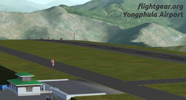
Yongphulla Airport
 Yongphula Airport | ||||||||||
| ||||||||||
| Type | Public | |||||||||
|---|---|---|---|---|---|---|---|---|---|---|
| City | Trashigang | |||||||||
| ||||||||||
| Scenery tile | e090n20 | |||||||||
| TerraSync | published | |||||||||
The Yongphulla Airport (VQ10) (also spelled Yonphula) is a small domestic airport situated 33Km SE from Trashigang town at an elevation of 2573 meter. It is currently one of four airports in Bhutan.
Flying at Yongphula
Some rules
- One direction of landing and takeoff is permitted. All aircraft shall land from RWY 12 and takeoff from RWY 30 due high obstacle toward RWY 30. No visual guidance like VASI. PAPI. ILS, Runway lights etc, available on final. Runway slope ranges from 4.7% to 5.3%
- No Radar facilities are available at Yonphula Aerodrome.
- No night landing/bad weather facilities
- Due to high terrain and steep mountains adjacent to the aerodrome, only flight in VMC is permitted. Only Day operations in visual meteorological conditions (VMC) is permitted. No SIDS (Standard Instrument Departure) is established for Yonphula airport. Therefore, all aircraft shall strictly follow in visual meteorological conditions (VMC).
- Strong anabatic wind in the afternoon may give raise to moderate to severe turbulence; it is recommended to restrict flight movement to the morning.
- Only one aircraft at a time is permitted to Descend in a valley.
- After landing, aircraft shall make right hand turn out on turn pad RWY30
- After departure climb initially 18 000 ft on QNH maintaining visual to terrain/obstacle and report over designated compulsory reporting points.
- Avoid flying over yellow rooftop i.e., (dzongs, monastery, temples)
- Flight shall be permitted to take-off and land between sunrise and sunset for all types of flight operations.
Runway 12/30
- RWY 12 Direction 124°
- RWY 30 Direction 304°
- NDB 367 Khz “YP” (Yongphulla) - 200 M SW of THR12
ATC
- ATIS - n/a
- Tower - n/a (118.20 Mhz)
- Ground - n/a
Airlines
- Druk Air
- Tashi Air
Top destinations
Domestic:
Regular aircraft
- ATR 42-500
Scenery
The development of the scenery The Kingdom of Bhutan started 2014. At this time, there were already 2 airports. Paro Intl. Airport and Yongphulla Airport (both available via TerraSync). But there is a lot more in this country.
Development themes:
- added Fixes, Navigational Aids and Airways
- added Layout (850-standard) with parking position, roads and windsocks for Bathpalathang and Gelephu approved
- updated Layout (850-standard) for Paro and Yongphula approved
- Realistic 3D models: Terminals, Control Towers, Instuments, Fances, Signs and more all Rembrandt ready
- AI Ground Network for all Bhutanese airports
- AI Liveries for airlines Druk Air and Tashi Air
- AI Traffic for both Bhutanese airlines
Download via mediafire
You can download the scenery The Kingdom of Bhutan for testing: download FGscenery_TKOB.zip (~3 MB)
Please read the Readme file and follow the instructions. The download contains the airports Gelephu, Bathpalathang and Yongphulla. Please set Terrasync to download the Paro Airport and Terrain automaticly.
Download via TerraSync
TerraSync has it all! Terrasync makes it easy for every user always to have the latest scenery installed automatically. If you want to test the new version of Yongphulla or Bhutan scenery download the latest version via mediafire.
- Updates:
- 2014-08 Terminal and other models published

